Saint-Jean-la-Bussière geodata
Saint-Jean-la-Bussière (Auvergne-Rhône-Alpes) is a populated place; located in France in Europe/Paris (GMT+2) time zone. With population of 910 people, there are 9574 cities with bigger population in this country. Compared to other cities in France, 66.2% of cities are located further ↑North; 70.8% of cities are located further ←West and 93.6% of cities have lower elevation than Saint-Jean-la-Bussière. Note1
Administrative division(s):
- Level 1: Auvergne-Rhône-Alpes
- Level 2: Département du Rhône
- Level 3: Arrondissement de Villefranche-sur-Saône
- Level 4: Saint-Jean-la-Bussière
Current local time in Saint-Jean-la-Bussière:
12:33 PM, SaturdayDifference from your time zone: hours


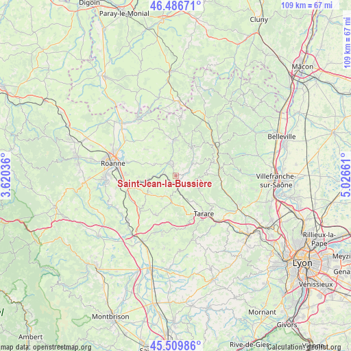
Saint-Jean-la-Bussière GPS coordinates[2]
46° 0' 1.584" North, 4° 19' 24.564" East
| Map corner | latitude | longitude |
|---|---|---|
| Upper-left | 46.48671°, | 3.62036° |
| Center: | 46.00044°, | 4.32349° |
| Lower-right: | 45.50986°, | 5.02661° |
| Map W x H: | 108.6×108.6 km | = 67.5×67.5mi |
| max Lat: | 51.07786° ⇑66.2% North |
| Saint-Jean-la-Bussière: | 46.00044° |
| min Lat: | ⇓33.8% South 41.3874° |
| min Long | Saint-Jean-la-B | max Long |
| -5.08615° | 4.32349° | 9.52242° |
| W 70.8%⇐ | ⇒29.2% E |
Elevation
Elevation of Saint-Jean-la-Bussière is 526 m = 1726 ft, and this is 332.3 m = 1090 ft above average elevation for this country.
| Max E: |
2333 m = 7654 ft | 6.4% |
| Saint-Jean-la-Bussière | 526 m 1726 ft | |
| Avg. | 193.7 m = 635 ft | |
Min E: |
-1 m = -3 ft | 93.6% |
See also: France elevation on elevation.city.
Geographical zone
Saint-Jean-la-Bussière is located in North temperate zone (between Tropic of Cancer and the Arctic Circle). Distance of this North polar circle is 2286.4 km =1420.7 mi to North.| Distance of | km | miles | from Saint-Jean-la-Bussière |
|---|---|---|---|
| North Pole | 4892.3 | 3039.9 | to North |
| Arctic Circle | 2286.4 | 1420.7 | to North |
| Tropic Cancer | 2508.9 | 1559 | to South |
| Equator | 5114.8 | 3178.2 | to South |


Nearby cities:
15 places around Saint-Jean-la-Bussière: (largest is in red/bold)
• Amplepuis
3.1 km =1.9 mi,  170°
170°
• Bourg-de-Thizy
4.2 km =2.6 mi,  332°
332°
• Cublize
4.6 km =2.9 mi,  64°
64°
• Fourneaux
7.9 km =4.9 mi,  210°
210°
• La Gresle
9 km =5.6 mi,  340°
340°
• Lay
10 km =6.2 mi,  238°
238°
• Les Sauvages
9.3 km =5.8 mi,  154°
154°
• Mardore
7.9 km =4.9 mi,  8°
8°
• Marnand
3.9 km =2.4 mi, 6°
• Pont-Trambouze
8 km =5 mi,  354°
354°
• Ronno
4.9 km =3 mi,  110°
110°
• Régny
8.3 km =5.2 mi,  262°
262°
• Saint-Victor-sur-Rhins
3.2 km =2 mi,  276°
276°
• Thizy-les-Bourgs
3.4 km =2.1 mi, 346°
• Valsonne
10.2 km =6.3 mi,  126°
126°
Sources, notices
• [Note1] Compared only with cities in France existing in our database
• [Src1] Map data: © OpenStreetMap contributors (CC-BY-SA)
• [Src2] Other city data from geonames.org with taken over terms of usage.
• [Src3] Geographical zone / Annual Mean Temperature by Robert A. Rohde @ Wikipedia
