Fourneaux geodata
Fourneaux (Auvergne-Rhône-Alpes) is a populated place; located in France in Europe/Paris (GMT+2) time zone. With population of 555 people, there are 14118 cities with bigger population in this country. Compared to other cities in France, 67.1% of cities are located further ↑North; 70.3% of cities are located further ←West and 92.8% of cities have lower elevation than Fourneaux. Note1
Administrative division(s):
- Level 1: Auvergne-Rhône-Alpes
- Level 2: Département de la Loire
- Level 3: Arrondissement de Roanne
- Level 4: Fourneaux


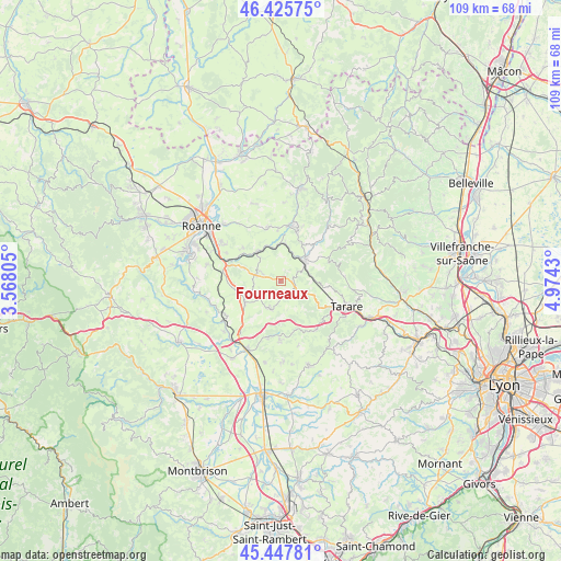
Fourneaux GPS coordinates[2]
45° 56' 20.184" North, 4° 16' 16.248" East
| Map corner | latitude | longitude |
|---|---|---|
| Upper-left | 46.42575°, | 3.56805° |
| Center: | 45.93894°, | 4.27118° |
| Lower-right: | 45.44781°, | 4.9743° |
| Map W x H: | 108.7×108.7 km | = 67.5×67.5mi |
| max Lat: | 51.07786° ⇑67.1% North |
| Fourneaux: | 45.93894° |
| min Lat: | ⇓32.9% South 41.3874° |
| min Long | Fourneaux | max Long |
| -5.08615° | 4.27118° | 9.52242° |
| W 70.3%⇐ | ⇒29.7% E |
Elevation
Elevation of Fourneaux is 498 m = 1634 ft, and this is 304.3 m = 998 ft above average elevation for this country.
| Max E: |
2333 m = 7654 ft | 7.2% |
| Fourneaux | 498 m 1634 ft | |
| Avg. | 193.7 m = 635 ft | |
Min E: |
-1 m = -3 ft | 92.8% |
See also: France elevation on elevation.city.
Geographical zone
Fourneaux is located in North temperate zone (between Tropic of Cancer and the Arctic Circle). Distance of this North polar circle is 2293.2 km =1424.9 mi to North.| Distance of | km | miles | from Fourneaux |
|---|---|---|---|
| North Pole | 4899.1 | 3044.2 | to North |
| Arctic Circle | 2293.2 | 1424.9 | to North |
| Tropic Cancer | 2502 | 1554.7 | to South |
| Equator | 5107.9 | 3173.9 | to South |


Nearby cities:
15 places around Fourneaux: (largest is in red/bold)
• Amplepuis
5.9 km =3.7 mi,  50°
50°
• Bourg-de-Thizy
10.8 km =6.7 mi,  11°
11°
• Joux
9.7 km =6 mi,  126°
126°
• Lay
4.7 km =2.9 mi,  289°
289°
• Les Sauvages
8.3 km =5.2 mi,  100°
100°
• Neulise
8.3 km =5.2 mi,  236°
236°
• Pradines
9.8 km =6.1 mi,  310°
310°
• Ronno
10 km =6.2 mi,  59°
59°
• Régny
7.2 km =4.5 mi,  323°
323°
• Saint-Jean-la-Bussière
7.9 km =4.9 mi,  30°
30°
• Saint-Just-la-Pendue
5.5 km =3.4 mi,  204°
204°
• Saint-Marcel-de-Félines
10 km =6.2 mi,  218°
218°
• Saint-Symphorien-de-Lay
4.6 km =2.9 mi,  282°
282°
• Saint-Victor-sur-Rhins
7.3 km =4.5 mi, 6°
• Thizy-les-Bourgs
10.6 km =6.6 mi,  17°
17°
Sources, notices
• [Note1] Compared only with cities in France existing in our database
• [Src1] Map data: © OpenStreetMap contributors (CC-BY-SA)
• [Src2] Other city data from geonames.org with taken over terms of usage.
• [Src3] Geographical zone / Annual Mean Temperature by Robert A. Rohde @ Wikipedia
