Régny geodata
Régny (Auvergne-Rhône-Alpes) is a populated place; located in France in Europe/Paris (GMT+2) time zone. With population of 1,642 people, there are 5686 cities with bigger population in this country. Compared to other cities in France, 66.4% of cities are located further ↑North; 69.9% of cities are located further ←West and 88.6% of cities have lower elevation than Régny. Note1
Administrative division(s):
- Level 1: Auvergne-Rhône-Alpes
- Level 2: Département de la Loire
- Level 3: Arrondissement de Roanne
- Level 4: Régny


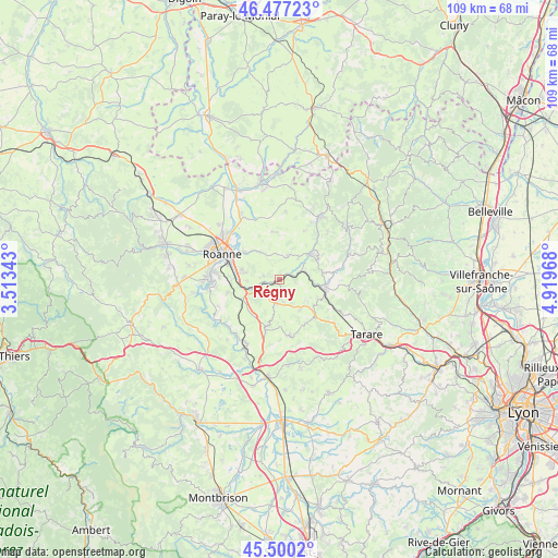
Régny GPS coordinates[2]
45° 59' 27.132" North, 4° 12' 59.58" East
| Map corner | latitude | longitude |
|---|---|---|
| Upper-left | 46.47723°, | 3.51343° |
| Center: | 45.99087°, | 4.21655° |
| Lower-right: | 45.5002°, | 4.91968° |
| Map W x H: | 108.6×108.6 km | = 67.5×67.5mi |
| max Lat: | 51.07786° ⇑66.4% North |
| Régny: | 45.99087° |
| min Lat: | ⇓33.6% South 41.3874° |
| min Long | Régny | max Long |
| -5.08615° | 4.21655° | 9.52242° |
| W 69.9%⇐ | ⇒30.1% E |
Elevation
Elevation of Régny is 400 m = 1312 ft, and this is 206.3 m = 677 ft above average elevation for this country.
| Max E: |
2333 m = 7654 ft | 11.4% |
| Régny | 400 m 1312 ft | |
| Avg. | 193.7 m = 635 ft | |
Min E: |
-1 m = -3 ft | 88.6% |
See also: France elevation on elevation.city.
Geographical zone
Régny is located in North temperate zone (between Tropic of Cancer and the Arctic Circle). Distance of this North polar circle is 2287.5 km =1421.4 mi to North.| Distance of | km | miles | from Régny |
|---|---|---|---|
| North Pole | 4893.4 | 3040.6 | to North |
| Arctic Circle | 2287.5 | 1421.4 | to North |
| Tropic Cancer | 2507.8 | 1558.3 | to South |
| Equator | 5113.7 | 3177.5 | to South |


Nearby cities:
15 places around Régny: (largest is in red/bold)
• Amplepuis
9 km =5.6 mi,  103°
103°
• Bourg-de-Thizy
8 km =5 mi,  53°
53°
• Coutouvre
9.2 km =5.7 mi,  354°
354°
• Fourneaux
7.2 km =4.5 mi,  143°
143°
• Lay
4.2 km =2.6 mi,  182°
182°
• Marnand
10 km =6.2 mi,  60°
60°
• Notre-Dame-de-Boisset
6.5 km =4 mi,  279°
279°
• Parigny
8.9 km =5.5 mi,  270°
270°
• Perreux
8.8 km =5.5 mi,  308°
308°
• Pradines
3.3 km =2.1 mi, 281°
• Saint-Jean-la-Bussière
8.3 km =5.2 mi,  82°
82°
• Saint-Symphorien-de-Lay
4.8 km =3 mi, 183°
• Saint-Victor-sur-Rhins
5.3 km =3.3 mi,  74°
74°
• Saint-Vincent-de-Boisset
7.5 km =4.7 mi, 284°
• Thizy-les-Bourgs
8.6 km =5.3 mi, 59°
Sources, notices
• [Note1] Compared only with cities in France existing in our database
• [Src1] Map data: © OpenStreetMap contributors (CC-BY-SA)
• [Src2] Other city data from geonames.org with taken over terms of usage.
• [Src3] Geographical zone / Annual Mean Temperature by Robert A. Rohde @ Wikipedia
