Amplepuis geodata
Amplepuis (Auvergne-Rhône-Alpes) is a populated place; located in France in Europe/Paris (GMT+2) time zone. With population of 5,261 people, there are 1870 cities with bigger population in this country. Compared to other cities in France, 66.6% of cities are located further ↑North; 70.8% of cities are located further ←West and 91.5% of cities have lower elevation than Amplepuis. Note1
Administrative division(s):
- Level 1: Auvergne-Rhône-Alpes
- Level 2: Département du Rhône
- Level 3: Arrondissement de Villefranche-sur-Saône
- Level 4: Amplepuis


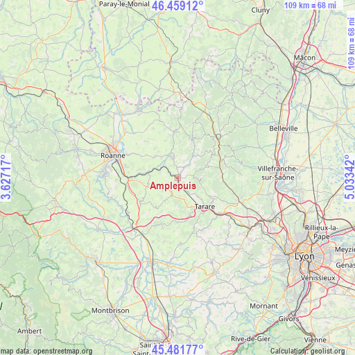
Amplepuis GPS coordinates[2]
45° 58' 21.36" North, 4° 19' 49.08" East
| Map corner | latitude | longitude |
|---|---|---|
| Upper-left | 46.45912°, | 3.62717° |
| Center: | 45.9726°, | 4.3303° |
| Lower-right: | 45.48177°, | 5.03342° |
| Map W x H: | 108.7×108.7 km | = 67.5×67.5mi |
| max Lat: | 51.07786° ⇑66.6% North |
| Amplepuis: | 45.9726° |
| min Lat: | ⇓33.4% South 41.3874° |
| min Long | Amplepuis | max Long |
| -5.08615° | 4.3303° | 9.52242° |
| W 70.8%⇐ | ⇒29.2% E |
Elevation
Elevation of Amplepuis is 462 m = 1516 ft, and this is 268.3 m = 880 ft above average elevation for this country.
| Max E: |
2333 m = 7654 ft | 8.5% |
| Amplepuis | 462 m 1516 ft | |
| Avg. | 193.7 m = 635 ft | |
Min E: |
-1 m = -3 ft | 91.5% |
See also: France elevation on elevation.city.
Geographical zone
Amplepuis is located in North temperate zone (between Tropic of Cancer and the Arctic Circle). Distance of this North polar circle is 2289.5 km =1422.6 mi to North.| Distance of | km | miles | from Amplepuis |
|---|---|---|---|
| North Pole | 4895.4 | 3041.9 | to North |
| Arctic Circle | 2289.5 | 1422.6 | to North |
| Tropic Cancer | 2505.8 | 1557 | to South |
| Equator | 5111.7 | 3176.3 | to South |


Nearby cities:
15 places around Amplepuis: (largest is in red/bold)
• Bourg-de-Thizy
7.2 km =4.5 mi,  340°
340°
• Cublize
6.2 km =3.9 mi,  35°
35°
• Fourneaux
5.9 km =3.7 mi,  230°
230°
• Joux
10 km =6.2 mi,  161°
161°
• Lay
9.2 km =5.7 mi,  256°
256°
• Les Sauvages
6.4 km =4 mi,  146°
146°
• Mardore
10.9 km =6.8 mi,  3°
3°
• Marnand
7 km =4.3 mi,  359°
359°
• Ronno
4.2 km =2.6 mi,  71°
71°
• Régny
9 km =5.6 mi,  283°
283°
• Saint-Jean-la-Bussière
3.1 km =1.9 mi,  350°
350°
• Saint-Symphorien-de-Lay
9.5 km =5.9 mi,  253°
253°
• Saint-Victor-sur-Rhins
5.1 km =3.2 mi,  313°
313°
• Thizy-les-Bourgs
6.5 km =4 mi, 348°
• Valsonne
8.2 km =5.1 mi,  110°
110°
Sources, notices
• [Note1] Compared only with cities in France existing in our database
• [Src1] Map data: © OpenStreetMap contributors (CC-BY-SA)
• [Src2] Other city data from geonames.org with taken over terms of usage.
• [Src3] Geographical zone / Annual Mean Temperature by Robert A. Rohde @ Wikipedia
