Asnières-la-Giraud geodata
Asnières-la-Giraud (Nouvelle-Aquitaine) is a populated place; located in France in Europe/Paris (GMT+2) time zone. With population of 942 people, there are 9275 cities with bigger population in this country. Compared to other cities in France, 67.8% of cities are located further ↑North; 83.7% of cities are located further →East and 84.9% of cities have higher elevation than Asnières-la-Giraud. Note1
Administrative division(s):
- Level 1: Nouvelle-Aquitaine
- Level 2: Charente-Maritime
- Level 3: Arrondissement de Saint-Jean-d'Angély
- Level 4: Asnières-la-Giraud


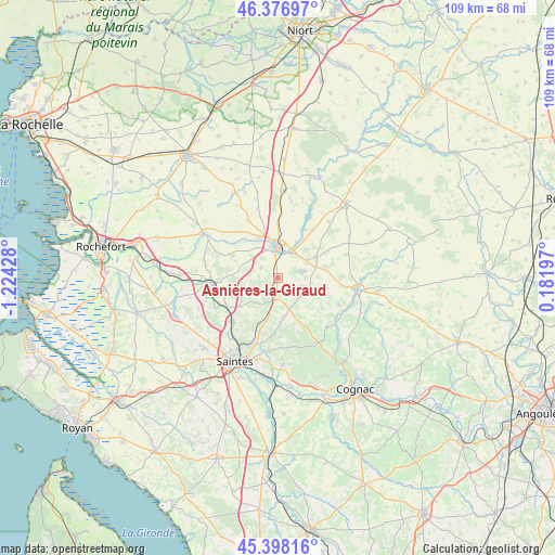
Asnières-la-Giraud GPS coordinates[2]
45° 53' 22.992" North, 0° 31' 16.14" West
| Map corner | latitude | longitude |
|---|---|---|
| Upper-left | 46.37697°, | -1.22428° |
| Center: | 45.88972°, | -0.52115° |
| Lower-right: | 45.39816°, | 0.18197° |
| Map W x H: | 108.8×108.8 km | = 67.6×67.6mi |
| max Lat: | 51.07786° ⇑67.8% North |
| Asnières-la-Giraud: | 45.88972° |
| min Lat: | ⇓32.2% South 41.3874° |
| min Long | Asnières-la-Gi | max Long |
| -5.08615° | -0.52115° | 9.52242° |
| W 16.3%⇐ | ⇒83.7% E |
Elevation
Elevation of Asnières-la-Giraud is 42 m = 138 ft, and this is 151.7 m = 498 ft below average elevation for this country.
| Max E: |
2333 m = 7654 ft | 84.9% |
| Avg. | 193.7 m = 635 ft | |
| Asnières-la-Giraud | 42 m = 138 ft | |
Min E: |
-1 m = -3 ft | 15.1% |
See also: France elevation on elevation.city.
Geographical zone
Asnières-la-Giraud is located in North temperate zone (between Tropic of Cancer and the Arctic Circle). Distance of this North polar circle is 2298.7 km =1428.3 mi to North.| Distance of | km | miles | from Asnières-la-Giraud |
|---|---|---|---|
| North Pole | 4904.6 | 3047.6 | to North |
| Arctic Circle | 2298.7 | 1428.3 | to North |
| Tropic Cancer | 2496.5 | 1551.3 | to South |
| Equator | 5102.5 | 3170.5 | to South |


Nearby cities:
15 places around Asnières-la-Giraud: (largest is in red/bold)
• Aumagne
9.2 km =5.7 mi,  100°
100°
• Brizambourg
8.1 km =5 mi,  157°
157°
• La Brousse
12.3 km =7.6 mi,  89°
89°
• La Vergne
9 km =5.6 mi,  338°
338°
• Landes
12.9 km =8 mi,  332°
332°
• Le Douhet
8.3 km =5.2 mi,  205°
205°
• Les Nouillers
12 km =7.5 mi,  292°
292°
• Mazeray
3.8 km =2.4 mi,  302°
302°
• Saint-Hilaire-de-Villefranche
4.4 km =2.7 mi,  188°
188°
• Saint-Jean-d’Angély
6.1 km =3.8 mi,  0°
0°
• Saint-Savinien
12.3 km =7.6 mi,  263°
263°
• Taillebourg
11.5 km =7.1 mi,  237°
237°
• Varaize
8.3 km =5.2 mi,  63°
63°
• Vénérand
11.1 km =6.9 mi, 194°
• Écoyeux
7.6 km =4.7 mi,  170°
170°
Sources, notices
• [Note1] Compared only with cities in France existing in our database
• [Src1] Map data: © OpenStreetMap contributors (CC-BY-SA)
• [Src2] Other city data from geonames.org with taken over terms of usage.
• [Src3] Geographical zone / Annual Mean Temperature by Robert A. Rohde @ Wikipedia
