Saint-Florent-sur-Cher geodata
Saint-Florent-sur-Cher (Centre) is a populated place; located in France in Europe/Paris (GMT+2) time zone. With population of 7,083 people, there are 1375 cities with bigger population in this country. Compared to other cities in France, 55.3% of cities are located further ↑North; 53.5% of cities are located further →East and 53.6% of cities have lower elevation than Saint-Florent-sur-Cher. Note1
Administrative division(s):
- Level 1: Centre
- Level 2: Cher
- Level 3: Arrondissement de Bourges
- Level 4: Saint-Florent-sur-Cher
Current local time in Saint-Florent-sur-Cher:
01:39 AM, SaturdayDifference from your time zone: hours


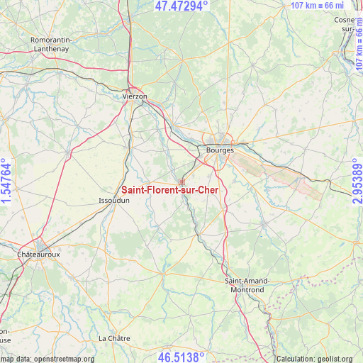
Saint-Florent-sur-Cher GPS coordinates[2]
46° 59' 43.872" North, 2° 15' 2.736" East
| Map corner | latitude | longitude |
|---|---|---|
| Upper-left | 47.47294°, | 1.54764° |
| Center: | 46.99552°, | 2.25076° |
| Lower-right: | 46.5138°, | 2.95389° |
| Map W x H: | 106.6×106.6 km | = 66.2×66.2mi |
| max Lat: | 51.07786° ⇑55.3% North |
| Saint-Florent-sur-Cher: | 46.99552° |
| min Lat: | ⇓44.7% South 41.3874° |
| min Long | Saint-Florent-s | max Long |
| -5.08615° | 2.25076° | 9.52242° |
| W 46.5%⇐ | ⇒53.5% E |
Elevation
Elevation of Saint-Florent-sur-Cher is 145 m = 476 ft, and this is 48.7 m = 160 ft below average elevation for this country.
| Max E: |
2333 m = 7654 ft | 46.4% |
| Avg. | 193.7 m = 635 ft | |
| Saint-Florent-sur-Cher | 145 m = 476 ft | |
Min E: |
-1 m = -3 ft | 53.6% |
See also: France elevation on elevation.city.
Geographical zone
Saint-Florent-sur-Cher is located in North temperate zone (between Tropic of Cancer and the Arctic Circle). Distance of this North polar circle is 2175.8 km =1352 mi to North.| Distance of | km | miles | from Saint-Florent-sur-Cher |
|---|---|---|---|
| North Pole | 4781.6 | 2971.1 | to North |
| Arctic Circle | 2175.8 | 1352 | to North |
| Tropic Cancer | 2619.5 | 1627.7 | to South |
| Equator | 5225.4 | 3246.9 | to South |


Nearby cities:
15 places around Saint-Florent-sur-Cher: (largest is in red/bold)
• Berry-Bouy
13 km =8.1 mi,  12°
12°
• Bourges
14.9 km =9.3 mi,  49°
49°
• Chârost
10.2 km =6.3 mi,  268°
268°
• Châteauneuf-sur-Cher
16.1 km =10 mi,  161°
161°
• Civray
6.7 km =4.2 mi,  241°
241°
• La Chapelle-Saint-Ursin
9.3 km =5.8 mi,  36°
36°
• Le Subdray
3.8 km =2.4 mi,  61°
61°
• Levet
14.2 km =8.8 mi,  123°
123°
• Lunery
6.8 km =4.2 mi,  168°
168°
• Mareuil-sur-Arnon
14.5 km =9 mi,  208°
208°
• Marmagne
11.9 km =7.4 mi, 11°
• Morthomiers
5 km =3.1 mi,  21°
21°
• Plaimpied-Givaudins
15.4 km =9.6 mi,  88°
88°
• Saint-Doulchard
14.3 km =8.9 mi,  32°
32°
• Trouy
8.5 km =5.3 mi,  77°
77°
Sources, notices
• [Note1] Compared only with cities in France existing in our database
• [Src1] Map data: © OpenStreetMap contributors (CC-BY-SA)
• [Src2] Other city data from geonames.org with taken over terms of usage.
• [Src3] Geographical zone / Annual Mean Temperature by Robert A. Rohde @ Wikipedia
