Saint-Doulchard geodata
Saint-Doulchard (Centre) is a populated place; located in France in Europe/Paris (GMT+2) time zone. With population of 9,433 people, there are 1017 cities with bigger population in this country. Compared to other cities in France, 54.2% of cities are located further ↑North; 51.8% of cities are located further →East and 51.7% of cities have lower elevation than Saint-Doulchard. Note1
Administrative division(s):
- Level 1: Centre
- Level 2: Cher
- Level 3: Arrondissement de Bourges
- Level 4: Saint-Doulchard


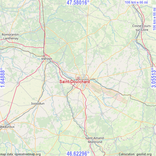
Saint-Doulchard GPS coordinates[2]
47° 6' 13.356" North, 2° 21' 7.2" East
| Map corner | latitude | longitude |
|---|---|---|
| Upper-left | 47.58016°, | 1.64888° |
| Center: | 47.10371°, | 2.352° |
| Lower-right: | 46.62296°, | 3.05513° |
| Map W x H: | 106.4×106.4 km | = 66.1×66.1mi |
| max Lat: | 51.07786° ⇑54.2% North |
| Saint-Doulchard: | 47.10371° |
| min Lat: | ⇓45.8% South 41.3874° |
| min Long | Saint-Doulchard | max Long |
| -5.08615° | 2.352° | 9.52242° |
| W 48.2%⇐ | ⇒51.8% E |
Elevation
Elevation of Saint-Doulchard is 138 m = 453 ft, and this is 55.7 m = 183 ft below average elevation for this country.
| Max E: |
2333 m = 7654 ft | 48.3% |
| Avg. | 193.7 m = 635 ft | |
| Saint-Doulchard | 138 m = 453 ft | |
Min E: |
-1 m = -3 ft | 51.7% |
See also: France elevation on elevation.city.
Geographical zone
Saint-Doulchard is located in North temperate zone (between Tropic of Cancer and the Arctic Circle). Distance of this North polar circle is 2163.7 km =1344.5 mi to North.| Distance of | km | miles | from Saint-Doulchard |
|---|---|---|---|
| North Pole | 4769.6 | 2963.7 | to North |
| Arctic Circle | 2163.7 | 1344.5 | to North |
| Tropic Cancer | 2631.5 | 1635.1 | to South |
| Equator | 5237.4 | 3254.4 | to South |


Nearby cities:
15 places around Saint-Doulchard: (largest is in red/bold)
• Allouis
11.6 km =7.2 mi,  306°
306°
• Berry-Bouy
4.8 km =3 mi,  278°
278°
• Bourges
4.3 km =2.7 mi,  121°
121°
• Fussy
7.4 km =4.6 mi,  52°
52°
• La Chapelle-Saint-Ursin
5 km =3.1 mi,  204°
204°
• Le Subdray
11.1 km =6.9 mi, 203°
• Marmagne
5.2 km =3.2 mi,  265°
265°
• Mehun-sur-Yèvre
11.3 km =7 mi,  289°
289°
• Morthomiers
9.4 km =5.8 mi,  218°
218°
• Pigny
10.4 km =6.5 mi,  39°
39°
• Saint-Georges-sur-Moulon
11.1 km =6.9 mi,  29°
29°
• Saint-Germain-du-Puy
9.9 km =6.2 mi,  92°
92°
• Saint-Éloy-de-Gy
5.8 km =3.6 mi,  353°
353°
• Trouy
10.3 km =6.4 mi,  176°
176°
• Vasselay
6.6 km =4.1 mi, 25°
Sources, notices
• [Note1] Compared only with cities in France existing in our database
• [Src1] Map data: © OpenStreetMap contributors (CC-BY-SA)
• [Src2] Other city data from geonames.org with taken over terms of usage.
• [Src3] Geographical zone / Annual Mean Temperature by Robert A. Rohde @ Wikipedia
