Bourges geodata
Bourges (Centre) is a seat of a second-order administrative division; located in France in Europe/Paris (GMT+2) time zone. With population of 67,987 people, there are 69 cities with bigger population in this country. Compared to other cities in France, 54.4% of cities are located further ↑North; 51.1% of cities are located further →East and 53.3% of cities have lower elevation than Bourges. Note1
Administrative division(s):
- Level 1: Centre
- Level 2: Cher
- Level 3: Arrondissement de Bourges
- Level 4: Bourges


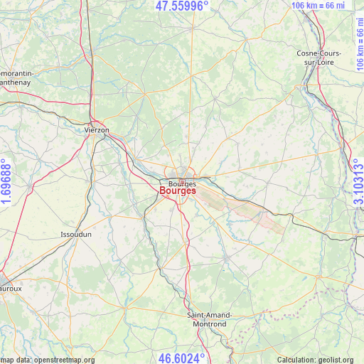
Bourges GPS coordinates[2]
47° 4' 59.988" North, 2° 24' 0" East
| Map corner | latitude | longitude |
|---|---|---|
| Upper-left | 47.55996°, | 1.69688° |
| Center: | 47.08333°, | 2.4° |
| Lower-right: | 46.6024°, | 3.10313° |
| Map W x H: | 106.5×106.5 km | = 66.2×66.2mi |
| max Lat: | 51.07786° ⇑54.4% North |
| Bourges: | 47.08333° |
| min Lat: | ⇓45.6% South 41.3874° |
| min Long | Bourges | max Long |
| -5.08615° | 2.4° | 9.52242° |
| W 48.9%⇐ | ⇒51.1% E |
Elevation
Elevation of Bourges is 144 m = 472 ft, and this is 49.7 m = 163 ft below average elevation for this country.
| Max E: |
2333 m = 7654 ft | 46.7% |
| Avg. | 193.7 m = 635 ft | |
| Bourges | 144 m = 472 ft | |
Min E: |
-1 m = -3 ft | 53.3% |
See also: Bourges elevation on elevation.city.
Geographical zone
Bourges is located in North temperate zone (between Tropic of Cancer and the Arctic Circle). Distance of this North polar circle is 2166 km =1345.9 mi to North.| Distance of | km | miles | from Bourges |
|---|---|---|---|
| North Pole | 4771.9 | 2965.1 | to North |
| Arctic Circle | 2166 | 1345.9 | to North |
| Tropic Cancer | 2629.3 | 1633.8 | to South |
| Equator | 5235.2 | 3253 | to South |


Nearby cities:
15 places around Bourges: (largest is in red/bold)
• Berry-Bouy
8.9 km =5.5 mi,  289°
289°
• Fussy
7.1 km =4.4 mi,  18°
18°
• La Chapelle-Saint-Ursin
6.2 km =3.9 mi,  247°
247°
• Le Subdray
11.2 km =7 mi,  225°
225°
• Marmagne
9 km =5.6 mi,  281°
281°
• Morthomiers
10.8 km =6.7 mi,  241°
241°
• Pigny
10.7 km =6.6 mi, 16°
• Plaimpied-Givaudins
10.3 km =6.4 mi,  156°
156°
• Saint-Doulchard
4.3 km =2.7 mi,  301°
301°
• Saint-Georges-sur-Moulon
12.1 km =7.5 mi,  8°
8°
• Saint-Germain-du-Puy
6.6 km =4.1 mi,  73°
73°
• Saint-Éloy-de-Gy
9.1 km =5.7 mi,  331°
331°
• Soye-en-Septaine
9.2 km =5.7 mi,  132°
132°
• Trouy
8.5 km =5.3 mi,  200°
200°
• Vasselay
8.2 km =5.1 mi,  354°
354°
Sources, notices
• [Note1] Compared only with cities in France existing in our database
• [Src1] Map data: © OpenStreetMap contributors (CC-BY-SA)
• [Src2] Other city data from geonames.org with taken over terms of usage.
• [Src3] Geographical zone / Annual Mean Temperature by Robert A. Rohde @ Wikipedia
