Berry-Bouy geodata
Berry-Bouy (Centre) is a populated place; located in France in Europe/Paris (GMT+2) time zone. With population of 950 people, there are 9204 cities with bigger population in this country. Compared to other cities in France, 54.1% of cities are located further ↑North; 52.9% of cities are located further →East and 50.2% of cities have higher elevation than Berry-Bouy. Note1
Administrative division(s):
- Level 1: Centre
- Level 2: Cher
- Level 3: Arrondissement de Vierzon
- Level 4: Berry-Bouy


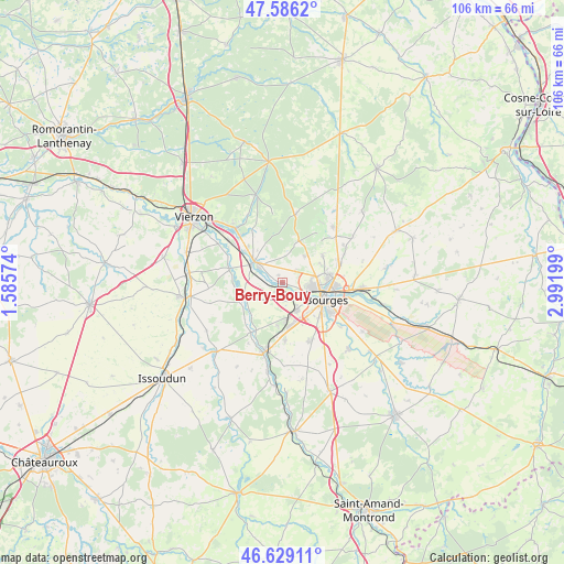
Berry-Bouy GPS coordinates[2]
47° 6' 35.316" North, 2° 17' 19.896" East
| Map corner | latitude | longitude |
|---|---|---|
| Upper-left | 47.5862°, | 1.58574° |
| Center: | 47.10981°, | 2.28886° |
| Lower-right: | 46.62911°, | 2.99199° |
| Map W x H: | 106.4×106.4 km | = 66.1×66.1mi |
| max Lat: | 51.07786° ⇑54.1% North |
| Berry-Bouy: | 47.10981° |
| min Lat: | ⇓45.9% South 41.3874° |
| min Long | Berry-Bouy | max Long |
| -5.08615° | 2.28886° | 9.52242° |
| W 47.1%⇐ | ⇒52.9% E |
Elevation
Elevation of Berry-Bouy is 131 m = 430 ft, and this is 62.7 m = 206 ft below average elevation for this country.
| Max E: |
2333 m = 7654 ft | 50.2% |
| Avg. | 193.7 m = 635 ft | |
| Berry-Bouy | 131 m = 430 ft | |
Min E: |
-1 m = -3 ft | 49.8% |
See also: France elevation on elevation.city.
Geographical zone
Berry-Bouy is located in North temperate zone (between Tropic of Cancer and the Arctic Circle). Distance of this North polar circle is 2163.1 km =1344.1 mi to North.| Distance of | km | miles | from Berry-Bouy |
|---|---|---|---|
| North Pole | 4768.9 | 2963.3 | to North |
| Arctic Circle | 2163.1 | 1344.1 | to North |
| Tropic Cancer | 2632.2 | 1635.6 | to South |
| Equator | 5238.1 | 3254.8 | to South |


Nearby cities:
15 places around Berry-Bouy: (largest is in red/bold)
• Allouis
7.7 km =4.8 mi,  323°
323°
• Bourges
8.9 km =5.5 mi,  109°
109°
• Foëcy
12.1 km =7.5 mi,  307°
307°
• Fussy
11.3 km =7 mi,  70°
70°
• La Chapelle-Saint-Ursin
5.9 km =3.7 mi,  152°
152°
• Le Subdray
10.9 km =6.8 mi,  177°
177°
• Marmagne
1.2 km =0.7 mi,  200°
200°
• Mehun-sur-Yèvre
6.7 km =4.2 mi,  297°
297°
• Morthomiers
8.1 km =5 mi,  187°
187°
• Quincy
10.3 km =6.4 mi,  284°
284°
• Saint-Doulchard
4.8 km =3 mi,  98°
98°
• Saint-Florent-sur-Cher
13 km =8.1 mi, 192°
• Saint-Éloy-de-Gy
6.5 km =4 mi,  38°
38°
• Trouy
12.2 km =7.6 mi, 153°
• Vasselay
9.2 km =5.7 mi,  55°
55°
Sources, notices
• [Note1] Compared only with cities in France existing in our database
• [Src1] Map data: © OpenStreetMap contributors (CC-BY-SA)
• [Src2] Other city data from geonames.org with taken over terms of usage.
• [Src3] Geographical zone / Annual Mean Temperature by Robert A. Rohde @ Wikipedia
