Sainte-Barbe geodata
Sainte-Barbe (Grand Est) is a populated place; located in France in Europe/Paris (GMT+2) time zone. With population of 727 people, there are 11442 cities with bigger population in this country. Compared to other cities in France, 83.5% of cities are located further ↓South; 90.2% of cities are located further ←West and 79.9% of cities have lower elevation than Sainte-Barbe. Note1
Administrative division(s):
- Level 1: Grand Est
- Level 2: Moselle
- Level 3: Arrondissement de Metz
- Level 4: Sainte-Barbe


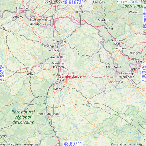
Sainte-Barbe GPS coordinates[2]
49° 9' 32.58" North, 6° 18' 2.232" East
| Map corner | latitude | longitude |
|---|---|---|
| Upper-left | 49.61673°, | 5.5975° |
| Center: | 49.15905°, | 6.30062° |
| Lower-right: | 48.6971°, | 7.00375° |
| Map W x H: | 102.3×102.3 km | = 63.6×63.6mi |
| max Lat: | 51.07786° ⇑16.5% North |
| Sainte-Barbe: | 49.15905° |
| min Lat: | ⇓83.5% South 41.3874° |
| min Long | Sainte-Barbe | max Long |
| -5.08615° | 6.30062° | 9.52242° |
| W 90.2%⇐ | ⇒9.8% E |
Elevation
Elevation of Sainte-Barbe is 289 m = 948 ft, and this is 95.3 m = 313 ft above average elevation for this country.
| Max E: |
2333 m = 7654 ft | 20.1% |
| Sainte-Barbe | 289 m 948 ft | |
| Avg. | 193.7 m = 635 ft | |
Min E: |
-1 m = -3 ft | 79.9% |
See also: France elevation on elevation.city.
Geographical zone
Sainte-Barbe is located in North temperate zone (between Tropic of Cancer and the Arctic Circle). Distance of this North polar circle is 1935.2 km =1202.5 mi to North.| Distance of | km | miles | from Sainte-Barbe |
|---|---|---|---|
| North Pole | 4541.1 | 2821.7 | to North |
| Arctic Circle | 1935.2 | 1202.5 | to North |
| Tropic Cancer | 2860.1 | 1777.2 | to South |
| Equator | 5466 | 3396.4 | to South |


Nearby cities:
15 places around Sainte-Barbe: (largest is in red/bold)
• Argancy
8.3 km =5.2 mi,  299°
299°
• Ars-Laquenexy
7.6 km =4.7 mi,  197°
197°
• Bettelainville
8.5 km =5.3 mi,  359°
359°
• Charly-Oradour
4.8 km =3 mi,  290°
290°
• Failly
2.8 km =1.7 mi,  266°
266°
• La Maxe
8.1 km =5 mi,  277°
277°
• Laquenexy
9 km =5.6 mi,  173°
173°
• Noisseville
3.4 km =2.1 mi,  214°
214°
• Pange
9.1 km =5.7 mi,  154°
154°
• Retonfey
2.5 km =1.6 mi, 170°
• Saint-Julien-lès-Metz
7.7 km =4.8 mi,  247°
247°
• Sanry-lès-Vigy
3 km =1.9 mi,  330°
330°
• Silly-sur-Nied
6.1 km =3.8 mi,  135°
135°
• Vantoux
6 km =3.7 mi,  236°
236°
• Vigy
5 km =3.1 mi, 358°
Sources, notices
• [Note1] Compared only with cities in France existing in our database
• [Src1] Map data: © OpenStreetMap contributors (CC-BY-SA)
• [Src2] Other city data from geonames.org with taken over terms of usage.
• [Src3] Geographical zone / Annual Mean Temperature by Robert A. Rohde @ Wikipedia
