Charly-Oradour geodata
Charly-Oradour (Grand Est) is a populated place; located in France in Europe/Paris (GMT+2) time zone. With population of 644 people, there are 12610 cities with bigger population in this country. Compared to other cities in France, 83.8% of cities are located further ↓South; 89.7% of cities are located further ←West and 67.4% of cities have lower elevation than Charly-Oradour. Note1
Administrative division(s):
- Level 1: Grand Est
- Level 2: Moselle
- Level 3: Arrondissement de Metz
- Level 4: Charly-Oradour


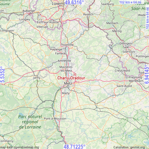
Charly-Oradour GPS coordinates[2]
49° 10' 26.616" North, 6° 14' 17.988" East
| Map corner | latitude | longitude |
|---|---|---|
| Upper-left | 49.6316°, | 5.5352° |
| Center: | 49.17406°, | 6.23833° |
| Lower-right: | 48.71225°, | 6.94145° |
| Map W x H: | 102.2×102.2 km | = 63.5×63.5mi |
| max Lat: | 51.07786° ⇑16.2% North |
| Charly-Oradour: | 49.17406° |
| min Lat: | ⇓83.8% South 41.3874° |
| min Long | Charly-Oradour | max Long |
| -5.08615° | 6.23833° | 9.52242° |
| W 89.7%⇐ | ⇒10.3% E |
Elevation
Elevation of Charly-Oradour is 206 m = 676 ft, and this is 12.3 m = 40 ft above average elevation for this country.
| Max E: |
2333 m = 7654 ft | 32.6% |
| Charly-Oradour | 206 m 676 ft | |
| Avg. | 193.7 m = 635 ft | |
Min E: |
-1 m = -3 ft | 67.4% |
See also: France elevation on elevation.city.
Geographical zone
Charly-Oradour is located in North temperate zone (between Tropic of Cancer and the Arctic Circle). Distance of this North polar circle is 1933.5 km =1201.4 mi to North.| Distance of | km | miles | from Charly-Oradour |
|---|---|---|---|
| North Pole | 4539.4 | 2820.7 | to North |
| Arctic Circle | 1933.5 | 1201.4 | to North |
| Tropic Cancer | 2861.7 | 1778.2 | to South |
| Equator | 5467.6 | 3397.4 | to South |


Nearby cities:
15 places around Charly-Oradour: (largest is in red/bold)
• Argancy
3.6 km =2.2 mi,  311°
311°
• Ennery
6 km =3.7 mi,  345°
345°
• Failly
2.5 km =1.6 mi,  137°
137°
• Flévy
7.1 km =4.4 mi,  3°
3°
• Hauconcourt
6.1 km =3.8 mi,  325°
325°
• La Maxe
3.6 km =2.2 mi,  259°
259°
• Maizières-lès-Metz
7.2 km =4.5 mi, 307°
• Noisseville
5.2 km =3.2 mi,  149°
149°
• Retonfey
6.5 km =4 mi,  130°
130°
• Saint-Julien-lès-Metz
5.3 km =3.3 mi,  209°
209°
• Sainte-Barbe
4.8 km =3 mi,  110°
110°
• Sanry-lès-Vigy
3.2 km =2 mi,  72°
72°
• Vantoux
5 km =3.1 mi,  185°
185°
• Vigy
5.6 km =3.5 mi,  52°
52°
• Woippy
6.8 km =4.2 mi,  248°
248°
Sources, notices
• [Note1] Compared only with cities in France existing in our database
• [Src1] Map data: © OpenStreetMap contributors (CC-BY-SA)
• [Src2] Other city data from geonames.org with taken over terms of usage.
• [Src3] Geographical zone / Annual Mean Temperature by Robert A. Rohde @ Wikipedia
