Alloue geodata
Alloue (Nouvelle-Aquitaine) is a populated place; located in France in Europe/Paris (GMT+2) time zone. With population of 505 people, there are 15148 cities with bigger population in this country. Compared to other cities in France, 65.9% of cities are located further ↑North; 73.3% of cities are located further →East and 61% of cities have lower elevation than Alloue. Note1
Administrative division(s):
- Level 1: Nouvelle-Aquitaine
- Level 2: Charente
- Level 3: Arrondissement de Confolens
- Level 4: Alloue


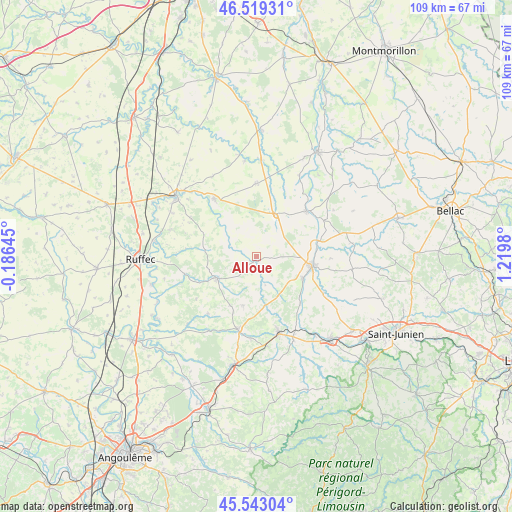
Alloue GPS coordinates[2]
46° 1' 59.988" North, 0° 31' 0.012" East
| Map corner | latitude | longitude |
|---|---|---|
| Upper-left | 46.51931°, | -0.18645° |
| Center: | 46.03333°, | 0.51667° |
| Lower-right: | 45.54304°, | 1.2198° |
| Map W x H: | 108.6×108.6 km | = 67.5×67.5mi |
| max Lat: | 51.07786° ⇑65.9% North |
| Alloue: | 46.03333° |
| min Lat: | ⇓34.1% South 41.3874° |
| min Long | Alloue | max Long |
| -5.08615° | 0.51667° | 9.52242° |
| W 26.7%⇐ | ⇒73.3% E |
Elevation
Elevation of Alloue is 175 m = 574 ft, and this is 18.7 m = 61 ft below average elevation for this country.
| Max E: |
2333 m = 7654 ft | 39% |
| Avg. | 193.7 m = 635 ft | |
| Alloue | 175 m = 574 ft | |
Min E: |
-1 m = -3 ft | 61% |
See also: France elevation on elevation.city.
Geographical zone
Alloue is located in North temperate zone (between Tropic of Cancer and the Arctic Circle). Distance of this North polar circle is 2282.7 km =1418.4 mi to North.| Distance of | km | miles | from Alloue |
|---|---|---|---|
| North Pole | 4888.6 | 3037.6 | to North |
| Arctic Circle | 2282.7 | 1418.4 | to North |
| Tropic Cancer | 2512.5 | 1561.2 | to South |
| Equator | 5118.4 | 3180.4 | to South |


Nearby cities:
15 places around Alloue: (largest is in red/bold)
• Ansac-sur-Vienne
10.9 km =6.8 mi,  114°
114°
• Availles-Limouzine
14.5 km =9 mi,  47°
47°
• Champagne-Mouton
9.5 km =5.9 mi,  240°
240°
• Charroux
15.1 km =9.4 mi,  324°
324°
• Confolens
12.2 km =7.6 mi,  100°
100°
• Esse
15.8 km =9.8 mi,  90°
90°
• Genouillé
16.1 km =10 mi,  300°
300°
• Lessac
12.8 km =8 mi,  72°
72°
• Loubert
14.3 km =8.9 mi,  157°
157°
• Manot
13.7 km =8.5 mi,  137°
137°
• Mauprévoir
15.6 km =9.7 mi,  0°
0°
• Nanteuil-en-Vallée
15.5 km =9.6 mi,  256°
256°
• Pressac
10.1 km =6.3 mi,  24°
24°
• Saint-Claud
15.9 km =9.9 mi,  194°
194°
• Saint-Laurent-de-Céris
10.6 km =6.6 mi,  195°
195°
Sources, notices
• [Note1] Compared only with cities in France existing in our database
• [Src1] Map data: © OpenStreetMap contributors (CC-BY-SA)
• [Src2] Other city data from geonames.org with taken over terms of usage.
• [Src3] Geographical zone / Annual Mean Temperature by Robert A. Rohde @ Wikipedia
