Champagne-Mouton geodata
Champagne-Mouton (Nouvelle-Aquitaine) is a populated place; located in France in Europe/Paris (GMT+2) time zone. With population of 1,013 people, there are 8749 cities with bigger population in this country. Compared to other cities in France, 66.4% of cities are located further ↑North; 74.2% of cities are located further →East and 53.3% of cities have lower elevation than Champagne-Mouton. Note1
Administrative division(s):
- Level 1: Nouvelle-Aquitaine
- Level 2: Charente
- Level 3: Arrondissement de Confolens
- Level 4: Champagne-Mouton


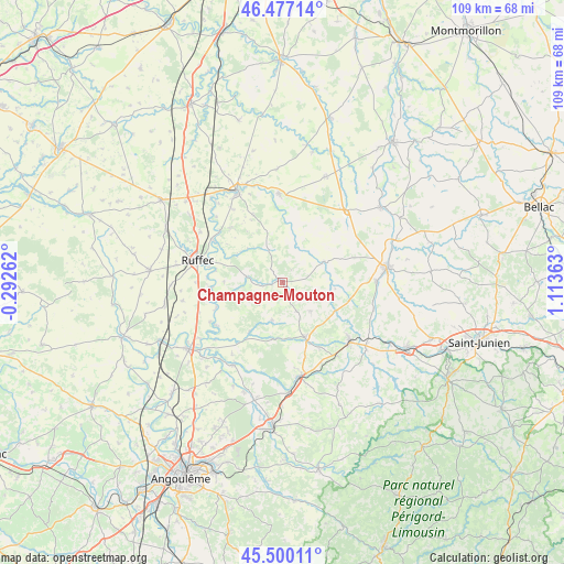
Champagne-Mouton GPS coordinates[2]
45° 59' 26.808" North, 0° 24' 37.836" East
| Map corner | latitude | longitude |
|---|---|---|
| Upper-left | 46.47714°, | -0.29262° |
| Center: | 45.99078°, | 0.41051° |
| Lower-right: | 45.50011°, | 1.11363° |
| Map W x H: | 108.6×108.6 km | = 67.5×67.5mi |
| max Lat: | 51.07786° ⇑66.4% North |
| Champagne-Mouton: | 45.99078° |
| min Lat: | ⇓33.6% South 41.3874° |
| min Long | Champagne-Mouto | max Long |
| -5.08615° | 0.41051° | 9.52242° |
| W 25.8%⇐ | ⇒74.2% E |
Elevation
Elevation of Champagne-Mouton is 144 m = 472 ft, and this is 49.7 m = 163 ft below average elevation for this country.
| Max E: |
2333 m = 7654 ft | 46.7% |
| Avg. | 193.7 m = 635 ft | |
| Champagne-Mouton | 144 m = 472 ft | |
Min E: |
-1 m = -3 ft | 53.3% |
See also: France elevation on elevation.city.
Geographical zone
Champagne-Mouton is located in North temperate zone (between Tropic of Cancer and the Arctic Circle). Distance of this North polar circle is 2287.5 km =1421.4 mi to North.| Distance of | km | miles | from Champagne-Mouton |
|---|---|---|---|
| North Pole | 4893.4 | 3040.6 | to North |
| Arctic Circle | 2287.5 | 1421.4 | to North |
| Tropic Cancer | 2507.8 | 1558.3 | to South |
| Equator | 5113.7 | 3177.5 | to South |


Nearby cities:
15 places around Champagne-Mouton: (largest is in red/bold)
• Alloue
9.5 km =5.9 mi,  60°
60°
• Ansac-sur-Vienne
18.1 km =11.2 mi,  89°
89°
• Charroux
17.1 km =10.6 mi,  358°
358°
• Genouillé
14.2 km =8.8 mi,  336°
336°
• Loubert
16 km =9.9 mi,  122°
122°
• Manot
18.3 km =11.4 mi,  106°
106°
• Nanteuil-en-Vallée
6.9 km =4.3 mi,  279°
279°
• Nieuil
14.3 km =8.9 mi,  150°
150°
• Roumazières-Loubert
17.5 km =10.9 mi,  131°
131°
• Ruffec
16.9 km =10.5 mi, 284°
• Saint-Angeau
18.5 km =11.5 mi,  211°
211°
• Saint-Claud
11.4 km =7.1 mi,  158°
158°
• Saint-Laurent-de-Céris
7.7 km =4.8 mi,  135°
135°
• Taizé-Aizie
15.8 km =9.8 mi,  301°
301°
• Verteuil-sur-Charente
13.9 km =8.6 mi,  265°
265°
Sources, notices
• [Note1] Compared only with cities in France existing in our database
• [Src1] Map data: © OpenStreetMap contributors (CC-BY-SA)
• [Src2] Other city data from geonames.org with taken over terms of usage.
• [Src3] Geographical zone / Annual Mean Temperature by Robert A. Rohde @ Wikipedia
