Saint-Beauzély geodata
Saint-Beauzély (Occitanie) is a populated place; located in France in Europe/Paris (GMT+2) time zone. With population of 554 people, there are 14131 cities with bigger population in this country. Compared to other cities in France, 85.8% of cities are located further ↑North; 57.2% of cities are located further ←West and 95.6% of cities have lower elevation than Saint-Beauzély. Note1
Administrative division(s):
- Level 1: Occitanie
- Level 2: Département de l'Aveyron
- Level 3: Arrondissement de Millau
- Level 4: Saint-Beauzély


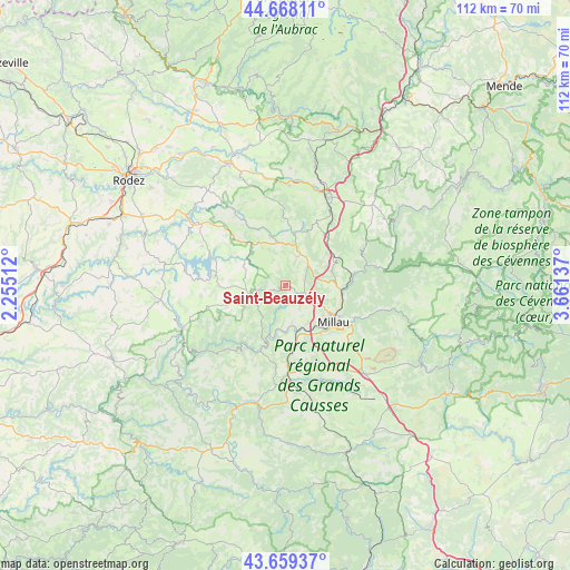
Saint-Beauzély GPS coordinates[2]
44° 9' 57.24" North, 2° 57' 29.7" East
| Map corner | latitude | longitude |
|---|---|---|
| Upper-left | 44.66811°, | 2.25512° |
| Center: | 44.1659°, | 2.95825° |
| Lower-right: | 43.65937°, | 3.66137° |
| Map W x H: | 112.2×112.2 km | = 69.7×69.7mi |
| max Lat: | 51.07786° ⇑85.8% North |
| Saint-Beauzély: | 44.1659° |
| min Lat: | ⇓14.2% South 41.3874° |
| min Long | Saint-Beauzély | max Long |
| -5.08615° | 2.95825° | 9.52242° |
| W 57.2%⇐ | ⇒42.8% E |
Elevation
Elevation of Saint-Beauzély is 618 m = 2028 ft, and this is 424.3 m = 1392 ft above average elevation for this country.
| Max E: |
2333 m = 7654 ft | 4.4% |
| Saint-Beauzély | 618 m 2028 ft | |
| Avg. | 193.7 m = 635 ft | |
Min E: |
-1 m = -3 ft | 95.6% |
See also: France elevation on elevation.city.
Geographical zone
Saint-Beauzély is located in North temperate zone (between Tropic of Cancer and the Arctic Circle). Distance of this Northern Tropic circle is 2304.9 km =1432.2 mi to South.| Distance of | km | miles | from Saint-Beauzély |
|---|---|---|---|
| North Pole | 5096.3 | 3166.7 | to North |
| Arctic Circle | 2490.4 | 1547.5 | to North |
| Tropic Cancer | 2304.9 | 1432.2 | to South |
| Equator | 4910.8 | 3051.4 | to South |


Nearby cities:
15 places around Saint-Beauzély: (largest is in red/bold)
• Aguessac
11.3 km =7 mi,  95°
95°
• Compeyre
11.5 km =7.1 mi,  92°
92°
• Creissels
12.1 km =7.5 mi,  137°
137°
• Lapanouse
19.9 km =12.4 mi,  16°
16°
• Millau
12.2 km =7.6 mi,  128°
128°
• Rivière-sur-Tarn
14.1 km =8.8 mi,  79°
79°
• Roquefort-sur-Soulzon
21.3 km =13.2 mi,  172°
172°
• Saint-Georges-de-Luzençon
11.5 km =7.1 mi, 168°
• Saint-Rome-de-Cernon
17 km =10.6 mi,  178°
178°
• Saint-Rome-de-Tarn
13.9 km =8.6 mi,  200°
200°
• Salles-Curan
13.7 km =8.5 mi,  277°
277°
• Ségur
17.2 km =10.7 mi,  324°
324°
• Sévérac-le-Château
19.4 km =12.1 mi, 24°
• Viala-du-Tarn
12.2 km =7.6 mi,  211°
211°
• Vézins-de-Lévézou
12.6 km =7.8 mi,  358°
358°
Sources, notices
• [Note1] Compared only with cities in France existing in our database
• [Src1] Map data: © OpenStreetMap contributors (CC-BY-SA)
• [Src2] Other city data from geonames.org with taken over terms of usage.
• [Src3] Geographical zone / Annual Mean Temperature by Robert A. Rohde @ Wikipedia
