Lapanouse geodata
Lapanouse (Occitanie) is a populated place; located in France in Europe/Paris (GMT+2) time zone. With population of 726 people, there are 11454 cities with bigger population in this country. Compared to other cities in France, 84.7% of cities are located further ↑North; 58.2% of cities are located further ←West and 96.3% of cities have lower elevation than Lapanouse. Note1
Administrative division(s):
- Level 1: Occitanie
- Level 2: Département de l'Aveyron
- Level 3: Arrondissement de Rodez
- Level 4: Sévérac d'Aveyron


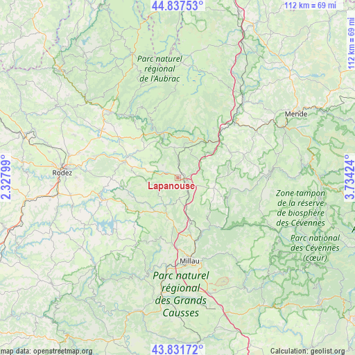
Lapanouse GPS coordinates[2]
44° 20' 12.408" North, 3° 1' 52.032" East
| Map corner | latitude | longitude |
|---|---|---|
| Upper-left | 44.83753°, | 2.32799° |
| Center: | 44.33678°, | 3.03112° |
| Lower-right: | 43.83172°, | 3.73424° |
| Map W x H: | 111.8×111.8 km | = 69.5×69.5mi |
| max Lat: | 51.07786° ⇑84.7% North |
| Lapanouse: | 44.33678° |
| min Lat: | ⇓15.3% South 41.3874° |
| min Long | Lapanouse | max Long |
| -5.08615° | 3.03112° | 9.52242° |
| W 58.2%⇐ | ⇒41.8% E |
Elevation
Elevation of Lapanouse is 665 m = 2182 ft, and this is 471.3 m = 1546 ft above average elevation for this country.
| Max E: |
2333 m = 7654 ft | 3.7% |
| Lapanouse | 665 m 2182 ft | |
| Avg. | 193.7 m = 635 ft | |
Min E: |
-1 m = -3 ft | 96.3% |
See also: France elevation on elevation.city.
Geographical zone
Lapanouse is located in North temperate zone (between Tropic of Cancer and the Arctic Circle). Distance of this Northern Tropic circle is 2323.9 km =1444 mi to South.| Distance of | km | miles | from Lapanouse |
|---|---|---|---|
| North Pole | 5077.3 | 3154.9 | to North |
| Arctic Circle | 2471.4 | 1535.7 | to North |
| Tropic Cancer | 2323.9 | 1444 | to South |
| Equator | 4929.8 | 3063.2 | to South |


Nearby cities:
15 places around Lapanouse: (largest is in red/bold)
• Aguessac
20.8 km =12.9 mi,  164°
164°
• Banassac
17.4 km =10.8 mi,  50°
50°
• Bertholène
21 km =13 mi,  288°
288°
• Castelnau-de-Mandailles
25.4 km =15.8 mi,  332°
332°
• Compeyre
20.3 km =12.6 mi, 163°
• La Canourgue
18.1 km =11.2 mi, 54°
• Laissac
17.4 km =10.8 mi, 286°
• Pont-de-Salars
24.9 km =15.5 mi,  255°
255°
• Rivière-sur-Tarn
18.3 km =11.4 mi,  154°
154°
• Saint-Beauzély
19.9 km =12.4 mi,  196°
196°
• Saint-Geniez-d’Olt
15.1 km =9.4 mi,  342°
342°
• Saint-Germain-du-Teil
19.4 km =12.1 mi,  35°
35°
• Ségur
16.4 km =10.2 mi,  252°
252°
• Sévérac-le-Château
2.6 km =1.6 mi,  121°
121°
• Vézins-de-Lévézou
8.9 km =5.5 mi,  224°
224°
Sources, notices
• [Note1] Compared only with cities in France existing in our database
• [Src1] Map data: © OpenStreetMap contributors (CC-BY-SA)
• [Src2] Other city data from geonames.org with taken over terms of usage.
• [Src3] Geographical zone / Annual Mean Temperature by Robert A. Rohde @ Wikipedia
