Millau geodata
Millau (Occitanie) is a seat of a third-order administrative division; located in France in Europe/Paris (GMT+2) time zone. With population of 23,307 people, there are 381 cities with bigger population in this country. Compared to other cities in France, 86.2% of cities are located further ↑North; 58.9% of cities are located further ←West and 85.6% of cities have lower elevation than Millau. Note1
Administrative division(s):
- Level 1: Occitanie
- Level 2: Département de l'Aveyron
- Level 3: Arrondissement de Millau
- Level 4: Millau


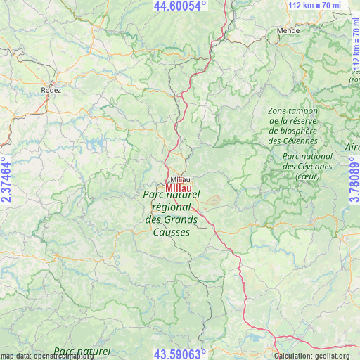
Millau GPS coordinates[2]
44° 5' 51.864" North, 3° 4' 39.972" East
| Map corner | latitude | longitude |
|---|---|---|
| Upper-left | 44.60054°, | 2.37464° |
| Center: | 44.09774°, | 3.07777° |
| Lower-right: | 43.59063°, | 3.78089° |
| Map W x H: | 112.3×112.3 km | = 69.8×69.8mi |
| max Lat: | 51.07786° ⇑86.2% North |
| Millau: | 44.09774° |
| min Lat: | ⇓13.8% South 41.3874° |
| min Long | Millau | max Long |
| -5.08615° | 3.07777° | 9.52242° |
| W 58.9%⇐ | ⇒41.1% E |
Elevation
Elevation of Millau is 354 m = 1161 ft, and this is 160.3 m = 526 ft above average elevation for this country.
| Max E: |
2333 m = 7654 ft | 14.4% |
| Millau | 354 m 1161 ft | |
| Avg. | 193.7 m = 635 ft | |
Min E: |
-1 m = -3 ft | 85.6% |
See also: France elevation on elevation.city.
Geographical zone
Millau is located in North temperate zone (between Tropic of Cancer and the Arctic Circle). Distance of this Northern Tropic circle is 2297.3 km =1427.5 mi to South.| Distance of | km | miles | from Millau |
|---|---|---|---|
| North Pole | 5103.9 | 3171.4 | to North |
| Arctic Circle | 2498 | 1552.2 | to North |
| Tropic Cancer | 2297.3 | 1427.5 | to South |
| Equator | 4903.2 | 3046.7 | to South |


Nearby cities:
15 places around Millau: (largest is in red/bold)
• Aguessac
6.7 km =4.2 mi,  14°
14°
• Compeyre
7.3 km =4.5 mi,  15°
15°
• Creissels
1.9 km =1.2 mi,  225°
225°
• La Cavalerie
11.7 km =7.3 mi,  146°
146°
• Nant
19.8 km =12.3 mi,  115°
115°
• Rivière-sur-Tarn
11 km =6.8 mi, 23°
• Roquefort-sur-Soulzon
15.3 km =9.5 mi,  207°
207°
• Saint-Affrique
21.8 km =13.5 mi,  223°
223°
• Saint-Beauzély
12.2 km =7.6 mi,  308°
308°
• Saint-Georges-de-Luzençon
8.2 km =5.1 mi,  243°
243°
• Saint-Jean-du-Bruel
24.2 km =15 mi,  110°
110°
• Saint-Rome-de-Cernon
13.1 km =8.1 mi, 223°
• Saint-Rome-de-Tarn
15.5 km =9.6 mi,  249°
249°
• Viala-du-Tarn
16.2 km =10.1 mi,  259°
259°
• Vézins-de-Lévézou
22.5 km =14 mi,  333°
333°
Sources, notices
• [Note1] Compared only with cities in France existing in our database
• [Src1] Map data: © OpenStreetMap contributors (CC-BY-SA)
• [Src2] Other city data from geonames.org with taken over terms of usage.
• [Src3] Geographical zone / Annual Mean Temperature by Robert A. Rohde @ Wikipedia
