Ruffec geodata
Ruffec (Nouvelle-Aquitaine) is a populated place; located in France in Europe/Paris (GMT+2) time zone. With population of 4,047 people, there are 2427 cities with bigger population in this country. Compared to other cities in France, 65.9% of cities are located further ↑North; 76.3% of cities are located further →East and 57.3% of cities have higher elevation than Ruffec. Note1
Administrative division(s):
- Level 1: Nouvelle-Aquitaine
- Level 2: Charente
- Level 3: Arrondissement de Confolens
- Level 4: Ruffec


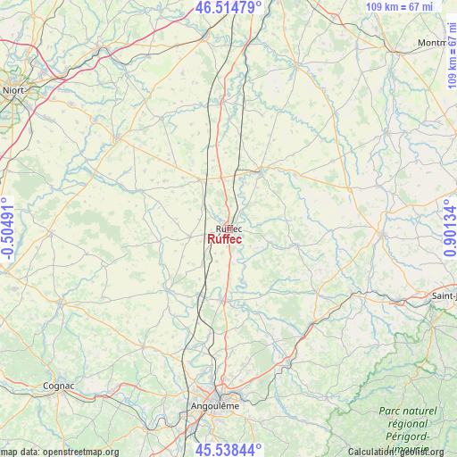
Ruffec GPS coordinates[2]
46° 1' 43.572" North, 0° 11' 53.556" East
| Map corner | latitude | longitude |
|---|---|---|
| Upper-left | 46.51479°, | -0.50491° |
| Center: | 46.02877°, | 0.19821° |
| Lower-right: | 45.53844°, | 0.90134° |
| Map W x H: | 108.6×108.6 km | = 67.5×67.5mi |
| max Lat: | 51.07786° ⇑65.9% North |
| Ruffec: | 46.02877° |
| min Lat: | ⇓34.1% South 41.3874° |
| min Long | Ruffec | max Long |
| -5.08615° | 0.19821° | 9.52242° |
| W 23.7%⇐ | ⇒76.3% E |
Elevation
Elevation of Ruffec is 110 m = 361 ft, and this is 83.7 m = 275 ft below average elevation for this country.
| Max E: |
2333 m = 7654 ft | 57.3% |
| Avg. | 193.7 m = 635 ft | |
| Ruffec | 110 m = 361 ft | |
Min E: |
-1 m = -3 ft | 42.7% |
See also: France elevation on elevation.city.
Geographical zone
Ruffec is located in North temperate zone (between Tropic of Cancer and the Arctic Circle). Distance of this North polar circle is 2283.3 km =1418.8 mi to North.| Distance of | km | miles | from Ruffec |
|---|---|---|---|
| North Pole | 4889.1 | 3037.9 | to North |
| Arctic Circle | 2283.3 | 1418.8 | to North |
| Tropic Cancer | 2512 | 1560.9 | to South |
| Equator | 5117.9 | 3180.1 | to South |


Nearby cities:
15 places around Ruffec: (largest is in red/bold)
• Blanzay
19.7 km =12.2 mi,  12°
12°
• Champagne-Mouton
16.9 km =10.5 mi,  104°
104°
• Civray
15.2 km =9.4 mi,  29°
29°
• Genouillé
13.8 km =8.6 mi,  50°
50°
• La Faye
4.1 km =2.5 mi,  256°
256°
• Limalonges
11.5 km =7.1 mi,  348°
348°
• Luxé
16.4 km =10.2 mi,  202°
202°
• Mansle
17.1 km =10.6 mi,  184°
184°
• Melleran
19 km =11.8 mi,  307°
307°
• Nanteuil-en-Vallée
10.1 km =6.3 mi,  107°
107°
• Sauzé-Vaussais
13.6 km =8.5 mi,  328°
328°
• Savigné
17.3 km =10.7 mi, 33°
• Taizé-Aizie
5 km =3.1 mi,  35°
35°
• Verteuil-sur-Charente
5.9 km =3.7 mi,  154°
154°
• Villefagnan
9.4 km =5.8 mi, 258°
Sources, notices
• [Note1] Compared only with cities in France existing in our database
• [Src1] Map data: © OpenStreetMap contributors (CC-BY-SA)
• [Src2] Other city data from geonames.org with taken over terms of usage.
• [Src3] Geographical zone / Annual Mean Temperature by Robert A. Rohde @ Wikipedia
