Nanteuil-en-Vallée geodata
Nanteuil-en-Vallée (Nouvelle-Aquitaine) is a populated place; located in France in Europe/Paris (GMT+2) time zone. With population of 1,427 people, there are 6496 cities with bigger population in this country. Compared to other cities in France, 66.2% of cities are located further ↑North; 75.1% of cities are located further →East and 57.6% of cities have higher elevation than Nanteuil-en-Vallée. Note1
Administrative division(s):
- Level 1: Nouvelle-Aquitaine
- Level 2: Charente
- Level 3: Arrondissement de Confolens
- Level 4: Nanteuil-en-Vallée


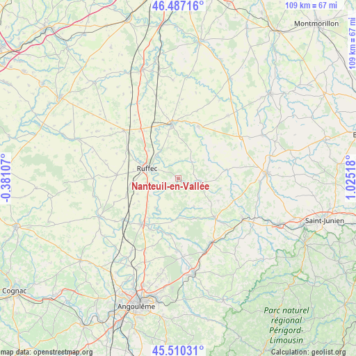
Nanteuil-en-Vallée GPS coordinates[2]
46° 0' 3.204" North, 0° 19' 19.416" East
| Map corner | latitude | longitude |
|---|---|---|
| Upper-left | 46.48716°, | -0.38107° |
| Center: | 46.00089°, | 0.32206° |
| Lower-right: | 45.51031°, | 1.02518° |
| Map W x H: | 108.6×108.6 km | = 67.5×67.5mi |
| max Lat: | 51.07786° ⇑66.2% North |
| Nanteuil-en-Vallée: | 46.00089° |
| min Lat: | ⇓33.8% South 41.3874° |
| min Long | Nanteuil-en-Val | max Long |
| -5.08615° | 0.32206° | 9.52242° |
| W 24.9%⇐ | ⇒75.1% E |
Elevation
Elevation of Nanteuil-en-Vallée is 109 m = 358 ft, and this is 84.7 m = 278 ft below average elevation for this country.
| Max E: |
2333 m = 7654 ft | 57.6% |
| Avg. | 193.7 m = 635 ft | |
| Nanteuil-en-Vallée | 109 m = 358 ft | |
Min E: |
-1 m = -3 ft | 42.4% |
See also: France elevation on elevation.city.
Geographical zone
Nanteuil-en-Vallée is located in North temperate zone (between Tropic of Cancer and the Arctic Circle). Distance of this North polar circle is 2286.4 km =1420.7 mi to North.| Distance of | km | miles | from Nanteuil-en-Vallée |
|---|---|---|---|
| North Pole | 4892.2 | 3039.9 | to North |
| Arctic Circle | 2286.4 | 1420.7 | to North |
| Tropic Cancer | 2508.9 | 1559 | to South |
| Equator | 5114.8 | 3178.2 | to South |


Nearby cities:
15 places around Nanteuil-en-Vallée: (largest is in red/bold)
• Alloue
15.5 km =9.6 mi,  76°
76°
• Champagne-Mouton
6.9 km =4.3 mi,  99°
99°
• Charroux
17.1 km =10.6 mi,  21°
21°
• Civray
16.5 km =10.3 mi,  352°
352°
• Genouillé
11.9 km =7.4 mi,  5°
5°
• La Faye
13.8 km =8.6 mi,  278°
278°
• Limalonges
18.6 km =11.6 mi,  320°
320°
• Mansle
17.8 km =11.1 mi,  218°
218°
• Ruffec
10.1 km =6.3 mi,  287°
287°
• Saint-Angeau
17.2 km =10.7 mi,  189°
189°
• Saint-Claud
16.1 km =10 mi,  136°
136°
• Saint-Laurent-de-Céris
13.9 km =8.6 mi,  118°
118°
• Savigné
17.6 km =10.9 mi,  359°
359°
• Taizé-Aizie
9.8 km =6.1 mi, 317°
• Verteuil-sur-Charente
7.4 km =4.6 mi,  252°
252°
Sources, notices
• [Note1] Compared only with cities in France existing in our database
• [Src1] Map data: © OpenStreetMap contributors (CC-BY-SA)
• [Src2] Other city data from geonames.org with taken over terms of usage.
• [Src3] Geographical zone / Annual Mean Temperature by Robert A. Rohde @ Wikipedia
