Précy-sur-Oise geodata
Précy-sur-Oise (Hauts-de-France) is a populated place; located in France in Europe/Paris (GMT+2) time zone. With population of 3,261 people, there are 2994 cities with bigger population in this country. Compared to other cities in France, 84.4% of cities are located further ↓South; 51.5% of cities are located further →East and 87.4% of cities have higher elevation than Précy-sur-Oise. Note1
Administrative division(s):
- Level 1: Hauts-de-France
- Level 2: Département de l'Oise
- Level 3: Arrondissement de Senlis
- Level 4: Précy-sur-Oise


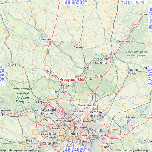
Précy-sur-Oise GPS coordinates[2]
49° 12' 28.044" North, 2° 22' 21.576" East
| Map corner | latitude | longitude |
|---|---|---|
| Upper-left | 49.66502°, | 1.66954° |
| Center: | 49.20779°, | 2.37266° |
| Lower-right: | 48.74629°, | 3.07579° |
| Map W x H: | 102.2×102.2 km | = 63.5×63.5mi |
| max Lat: | 51.07786° ⇑15.6% North |
| Précy-sur-Oise: | 49.20779° |
| min Lat: | ⇓84.4% South 41.3874° |
| min Long | Précy-sur-Oise | max Long |
| -5.08615° | 2.37266° | 9.52242° |
| W 48.5%⇐ | ⇒51.5% E |
Elevation
Elevation of Précy-sur-Oise is 36 m = 118 ft, and this is 157.7 m = 517 ft below average elevation for this country.
| Max E: |
2333 m = 7654 ft | 87.4% |
| Avg. | 193.7 m = 635 ft | |
| Précy-sur-Oise | 36 m = 118 ft | |
Min E: |
-1 m = -3 ft | 12.6% |
See also: France elevation on elevation.city.
Geographical zone
Précy-sur-Oise is located in North temperate zone (between Tropic of Cancer and the Arctic Circle). Distance of this North polar circle is 1929.8 km =1199.1 mi to North.| Distance of | km | miles | from Précy-sur-Oise |
|---|---|---|---|
| North Pole | 4535.7 | 2818.4 | to North |
| Arctic Circle | 1929.8 | 1199.1 | to North |
| Tropic Cancer | 2865.5 | 1780.5 | to South |
| Equator | 5471.4 | 3399.8 | to South |


Nearby cities:
15 places around Précy-sur-Oise: (largest is in red/bold)
• Blaincourt-lès-Précy
3.3 km =2.1 mi,  329°
329°
• Boran-sur-Oise
4.6 km =2.9 mi,  193°
193°
• Bruyères-sur-Oise
6.5 km =4 mi,  211°
211°
• Chantilly
7.3 km =4.5 mi,  101°
101°
• Cires-lès-Mello
7.3 km =4.5 mi,  351°
351°
• Cramoisy
5.7 km =3.5 mi,  21°
21°
• Crouy-en-Thelle
3.8 km =2.4 mi,  281°
281°
• Ercuis
5.8 km =3.6 mi,  300°
300°
• Gouvieux
3.8 km =2.4 mi,  127°
127°
• Le Mesnil-en-Thelle
7.1 km =4.4 mi,  242°
242°
• Neuilly-en-Thelle
6.6 km =4.1 mi,  286°
286°
• Saint-Maximin
6.1 km =3.8 mi,  75°
75°
• Saint-Vaast-lès-Mello
6.8 km =4.2 mi,  11°
11°
• Thiverny
6.7 km =4.2 mi,  43°
43°
• Villers-sous-Saint-Leu
1.7 km =1.1 mi,  72°
72°
Sources, notices
• [Note1] Compared only with cities in France existing in our database
• [Src1] Map data: © OpenStreetMap contributors (CC-BY-SA)
• [Src2] Other city data from geonames.org with taken over terms of usage.
• [Src3] Geographical zone / Annual Mean Temperature by Robert A. Rohde @ Wikipedia
