Chantilly geodata
Chantilly (Hauts-de-France) is a populated place; located in France in Europe/Paris (GMT+2) time zone. With population of 11,085 people, there are 868 cities with bigger population in this country. Compared to other cities in France, 84.1% of cities are located further ↓South; 50.1% of cities are located further ←West and 80.6% of cities have higher elevation than Chantilly. Note1
Administrative division(s):
- Level 1: Hauts-de-France
- Level 2: Département de l'Oise
- Level 3: Arrondissement de Senlis
- Level 4: Chantilly


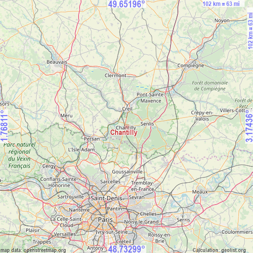
Chantilly GPS coordinates[2]
49° 11' 40.596" North, 2° 28' 16.464" East
| Map corner | latitude | longitude |
|---|---|---|
| Upper-left | 49.65196°, | 1.76811° |
| Center: | 49.19461°, | 2.47124° |
| Lower-right: | 48.73299°, | 3.17436° |
| Map W x H: | 102.2×102.2 km | = 63.5×63.5mi |
| max Lat: | 51.07786° ⇑15.9% North |
| Chantilly: | 49.19461° |
| min Lat: | ⇓84.1% South 41.3874° |
| min Long | Chantilly | max Long |
| -5.08615° | 2.47124° | 9.52242° |
| W 50.1%⇐ | ⇒49.9% E |
Elevation
Elevation of Chantilly is 53 m = 174 ft, and this is 140.7 m = 462 ft below average elevation for this country.
| Max E: |
2333 m = 7654 ft | 80.6% |
| Avg. | 193.7 m = 635 ft | |
| Chantilly | 53 m = 174 ft | |
Min E: |
-1 m = -3 ft | 19.4% |
See also: France elevation on elevation.city.
Geographical zone
Chantilly is located in North temperate zone (between Tropic of Cancer and the Arctic Circle). Distance of this North polar circle is 1931.2 km =1200 mi to North.| Distance of | km | miles | from Chantilly |
|---|---|---|---|
| North Pole | 4537.1 | 2819.2 | to North |
| Arctic Circle | 1931.2 | 1200 | to North |
| Tropic Cancer | 2864 | 1779.6 | to South |
| Equator | 5469.9 | 3398.8 | to South |


Nearby cities:
15 places around Chantilly: (largest is in red/bold)
• Apremont
4.2 km =2.6 mi,  39°
39°
• Aumont-en-Halatte
7.2 km =4.5 mi,  53°
53°
• Avilly-Saint-Léonard
5.1 km =3.2 mi,  90°
90°
• Courteuil
4.6 km =2.9 mi,  82°
82°
• Coye-la-Forêt
5.8 km =3.6 mi,  180°
180°
• Creil
7 km =4.3 mi,  8°
8°
• Gouvieux
4.2 km =2.6 mi,  258°
258°
• Lamorlaye
4 km =2.5 mi,  206°
206°
• Orry-la-Ville
7.4 km =4.6 mi,  156°
156°
• Pontarmé
7.4 km =4.6 mi,  128°
128°
• Précy-sur-Oise
7.3 km =4.5 mi,  281°
281°
• Saint-Maximin
3.3 km =2.1 mi,  337°
337°
• Thiverny
6.9 km =4.3 mi, 338°
• Villers-sous-Saint-Leu
5.9 km =3.7 mi,  289°
289°
• Vineuil-Saint-Firmin
1.9 km =1.2 mi,  70°
70°
Sources, notices
• [Note1] Compared only with cities in France existing in our database
• [Src1] Map data: © OpenStreetMap contributors (CC-BY-SA)
• [Src2] Other city data from geonames.org with taken over terms of usage.
• [Src3] Geographical zone / Annual Mean Temperature by Robert A. Rohde @ Wikipedia
