Plombières-les-Bains geodata
Plombières-les-Bains (Grand Est) is a populated place; located in France in Europe/Paris (GMT+2) time zone. With population of 1,943 people, there are 4925 cities with bigger population in this country. Compared to other cities in France, 58.6% of cities are located further ↓South; 91.5% of cities are located further ←West and 90% of cities have lower elevation than Plombières-les-Bains. Note1
Administrative division(s):
- Level 1: Grand Est
- Level 2: Vosges
- Level 3: Arrondissement d’Épinal
- Level 4: Plombières-les-Bains


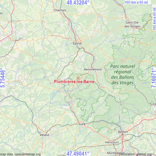
Plombières-les-Bains GPS coordinates[2]
47° 57' 48.132" North, 6° 27' 27.288" East
| Map corner | latitude | longitude |
|---|---|---|
| Upper-left | 48.43204°, | 5.75446° |
| Center: | 47.96337°, | 6.45758° |
| Lower-right: | 47.49041°, | 7.16071° |
| Map W x H: | 104.7×104.7 km | = 65.1×65.1mi |
| max Lat: | 51.07786° ⇑41.4% North |
| Plombières-les-Bains: | 47.96337° |
| min Lat: | ⇓58.6% South 41.3874° |
| min Long | Plombières-les | max Long |
| -5.08615° | 6.45758° | 9.52242° |
| W 91.5%⇐ | ⇒8.5% E |
Elevation
Elevation of Plombières-les-Bains is 426 m = 1398 ft, and this is 232.3 m = 762 ft above average elevation for this country.
| Max E: |
2333 m = 7654 ft | 10% |
| Plombières-les-Bains | 426 m 1398 ft | |
| Avg. | 193.7 m = 635 ft | |
Min E: |
-1 m = -3 ft | 90% |
See also: France elevation on elevation.city.
Geographical zone
Plombières-les-Bains is located in North temperate zone (between Tropic of Cancer and the Arctic Circle). Distance of this North polar circle is 2068.1 km =1285.1 mi to North.| Distance of | km | miles | from Plombières-les-Bains |
|---|---|---|---|
| North Pole | 4674 | 2904.3 | to North |
| Arctic Circle | 2068.1 | 1285.1 | to North |
| Tropic Cancer | 2727.1 | 1694.5 | to South |
| Equator | 5333 | 3313.8 | to South |


Nearby cities:
15 places around Plombières-les-Bains: (largest is in red/bold)
• Aillevillers-et-Lyaumont
10.1 km =6.3 mi,  241°
241°
• Bellefontaine
5.6 km =3.5 mi,  349°
349°
• Corbenay
12.3 km =7.6 mi,  230°
230°
• Dommartin-lès-Remiremont
14.2 km =8.8 mi,  73°
73°
• Fougerolles
9.5 km =5.9 mi,  204°
204°
• Hadol
14.1 km =8.8 mi,  5°
5°
• La Chapelle-aux-Bois
12.3 km =7.6 mi,  311°
311°
• Le Clerjus
9.9 km =6.2 mi,  269°
269°
• Raddon-et-Chapendu
13.3 km =8.3 mi,  174°
174°
• Raon-aux-Bois
11.4 km =7.1 mi,  24°
24°
• Remiremont
11.4 km =7.1 mi,  58°
58°
• Saint-Nabord
13.5 km =8.4 mi,  43°
43°
• Saint-Étienne-lès-Remiremont
13 km =8.1 mi, 59°
• Vecoux
13.4 km =8.3 mi,  83°
83°
• Xertigny
9.7 km =6 mi,  337°
337°
Sources, notices
• [Note1] Compared only with cities in France existing in our database
• [Src1] Map data: © OpenStreetMap contributors (CC-BY-SA)
• [Src2] Other city data from geonames.org with taken over terms of usage.
• [Src3] Geographical zone / Annual Mean Temperature by Robert A. Rohde @ Wikipedia
