Alvignac geodata
Alvignac (Occitanie) is a populated place; located in France in Europe/Paris (GMT+2) time zone. With population of 645 people, there are 12593 cities with bigger population in this country. Compared to other cities in France, 81.2% of cities are located further ↑North; 60.5% of cities are located further →East and 86.4% of cities have lower elevation than Alvignac. Note1
Administrative division(s):
- Level 1: Occitanie
- Level 2: Lot
- Level 3: Arrondissement de Gourdon
- Level 4: Alvignac


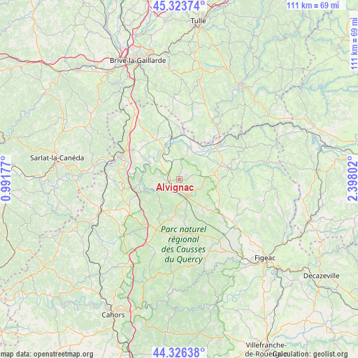
Alvignac GPS coordinates[2]
44° 49' 37.992" North, 1° 41' 41.604" East
| Map corner | latitude | longitude |
|---|---|---|
| Upper-left | 45.32374°, | 0.99177° |
| Center: | 44.82722°, | 1.69489° |
| Lower-right: | 44.32638°, | 2.39802° |
| Map W x H: | 110.9×110.9 km | = 68.9×68.9mi |
| max Lat: | 51.07786° ⇑81.2% North |
| Alvignac: | 44.82722° |
| min Lat: | ⇓18.8% South 41.3874° |
| min Long | Alvignac | max Long |
| -5.08615° | 1.69489° | 9.52242° |
| W 39.5%⇐ | ⇒60.5% E |
Elevation
Elevation of Alvignac is 366 m = 1201 ft, and this is 172.3 m = 565 ft above average elevation for this country.
| Max E: |
2333 m = 7654 ft | 13.6% |
| Alvignac | 366 m 1201 ft | |
| Avg. | 193.7 m = 635 ft | |
Min E: |
-1 m = -3 ft | 86.4% |
See also: France elevation on elevation.city.
Geographical zone
Alvignac is located in North temperate zone (between Tropic of Cancer and the Arctic Circle). Distance of this Northern Tropic circle is 2378.4 km =1477.9 mi to South.| Distance of | km | miles | from Alvignac |
|---|---|---|---|
| North Pole | 5022.7 | 3121 | to North |
| Arctic Circle | 2416.9 | 1501.8 | to North |
| Tropic Cancer | 2378.4 | 1477.9 | to South |
| Equator | 4984.3 | 3097.1 | to South |


Nearby cities:
15 places around Alvignac: (largest is in red/bold)
• Aynac
13.3 km =8.3 mi,  110°
110°
• Biars-sur-Cère
16.7 km =10.4 mi,  48°
48°
• Bretenoux
15 km =9.3 mi, 49°
• Bétaille
13.4 km =8.3 mi,  13°
13°
• Gramat
5.5 km =3.4 mi,  159°
159°
• Lanzac
17.5 km =10.9 mi,  287°
287°
• Leyme
16.7 km =10.4 mi, 105°
• Martel
13.9 km =8.6 mi,  330°
330°
• Pinsac
14.6 km =9.1 mi,  282°
282°
• Prudhomat
13 km =8.1 mi, 52°
• Puybrun
12.5 km =7.8 mi,  35°
35°
• Rocamadour
6.7 km =4.2 mi,  243°
243°
• Saint-Céré
16.1 km =10 mi,  77°
77°
• Saint-Laurent-les-Tours
16.8 km =10.4 mi,  70°
70°
• Vayrac
14 km =8.7 mi,  2°
2°
Sources, notices
• [Note1] Compared only with cities in France existing in our database
• [Src1] Map data: © OpenStreetMap contributors (CC-BY-SA)
• [Src2] Other city data from geonames.org with taken over terms of usage.
• [Src3] Geographical zone / Annual Mean Temperature by Robert A. Rohde @ Wikipedia
