Danjoutin geodata
Danjoutin (Bourgogne-Franche-Comté) is a populated place; located in France in Europe/Paris (GMT+2) time zone. With population of 3,527 people, there are 2759 cities with bigger population in this country. Compared to other cities in France, 52.9% of cities are located further ↓South; 94% of cities are located further ←West and 86.5% of cities have lower elevation than Danjoutin. Note1
Administrative division(s):
- Level 1: Bourgogne-Franche-Comté
- Level 2: Territoire de Belfort
- Level 3: Arrondissement de Belfort
- Level 4: Danjoutin


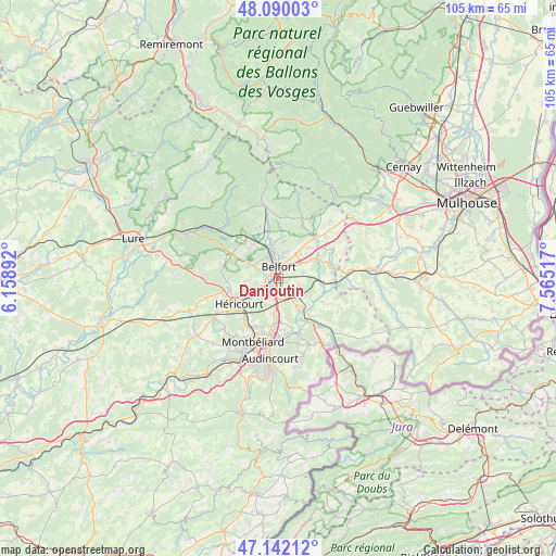
Danjoutin GPS coordinates[2]
47° 37' 5.592" North, 6° 51' 43.344" East
| Map corner | latitude | longitude |
|---|---|---|
| Upper-left | 48.09003°, | 6.15892° |
| Center: | 47.61822°, | 6.86204° |
| Lower-right: | 47.14212°, | 7.56517° |
| Map W x H: | 105.4×105.4 km | = 65.5×65.5mi |
| max Lat: | 51.07786° ⇑47.1% North |
| Danjoutin: | 47.61822° |
| min Lat: | ⇓52.9% South 41.3874° |
| min Long | Danjoutin | max Long |
| -5.08615° | 6.86204° | 9.52242° |
| W 94%⇐ | ⇒6% E |
Elevation
Elevation of Danjoutin is 367 m = 1204 ft, and this is 173.3 m = 569 ft above average elevation for this country.
| Max E: |
2333 m = 7654 ft | 13.5% |
| Danjoutin | 367 m 1204 ft | |
| Avg. | 193.7 m = 635 ft | |
Min E: |
-1 m = -3 ft | 86.5% |
See also: France elevation on elevation.city.
Geographical zone
Danjoutin is located in North temperate zone (between Tropic of Cancer and the Arctic Circle). Distance of this North polar circle is 2106.5 km =1308.9 mi to North.| Distance of | km | miles | from Danjoutin |
|---|---|---|---|
| North Pole | 4712.4 | 2928.1 | to North |
| Arctic Circle | 2106.5 | 1308.9 | to North |
| Tropic Cancer | 2688.7 | 1670.7 | to South |
| Equator | 5294.6 | 3289.9 | to South |


Nearby cities:
15 places around Danjoutin: (largest is in red/bold)
• Andelnans
1.8 km =1.1 mi,  169°
169°
• Bavilliers
2 km =1.2 mi,  282°
282°
• Belfort
2.7 km =1.7 mi,  347°
347°
• Bessoncourt
6 km =3.7 mi,  60°
60°
• Chèvremont
4.5 km =2.8 mi,  74°
74°
• Cravanche
4.5 km =2.8 mi,  330°
330°
• Denney
6.2 km =3.9 mi,  42°
42°
• Dorans
3.7 km =2.3 mi,  208°
208°
• Essert
3.8 km =2.4 mi,  296°
296°
• Meroux
3.7 km =2.3 mi,  132°
132°
• Offemont
5.1 km =3.2 mi,  13°
13°
• Pérouse
3 km =1.9 mi,  46°
46°
• Sevenans
3.5 km =2.2 mi, 174°
• Valdoie
6 km =3.7 mi, 345°
• Vézelois
4.1 km =2.5 mi,  105°
105°
Sources, notices
• [Note1] Compared only with cities in France existing in our database
• [Src1] Map data: © OpenStreetMap contributors (CC-BY-SA)
• [Src2] Other city data from geonames.org with taken over terms of usage.
• [Src3] Geographical zone / Annual Mean Temperature by Robert A. Rohde @ Wikipedia
