Belfort geodata
Belfort (Bourgogne-Franche-Comté) is a seat of a second-order administrative division; located in France in Europe/Paris (GMT+2) time zone. With population of 54,562 people, there are 98 cities with bigger population in this country. Compared to other cities in France, 53.3% of cities are located further ↓South; 94% of cities are located further ←West and 86.2% of cities have lower elevation than Belfort. Note1
Administrative division(s):
- Level 1: Bourgogne-Franche-Comté
- Level 2: Territoire de Belfort
- Level 3: Arrondissement de Belfort
- Level 4: Belfort


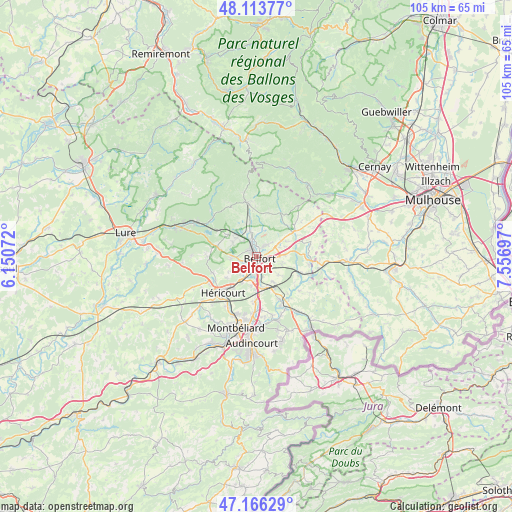
Belfort GPS coordinates[2]
47° 38' 31.848" North, 6° 51' 13.86" East
| Map corner | latitude | longitude |
|---|---|---|
| Upper-left | 48.11377°, | 6.15072° |
| Center: | 47.64218°, | 6.85385° |
| Lower-right: | 47.16629°, | 7.55697° |
| Map W x H: | 105.3×105.3 km | = 65.4×65.4mi |
| max Lat: | 51.07786° ⇑46.7% North |
| Belfort: | 47.64218° |
| min Lat: | ⇓53.3% South 41.3874° |
| min Long | Belfort | max Long |
| -5.08615° | 6.85385° | 9.52242° |
| W 94%⇐ | ⇒6% E |
Elevation
Elevation of Belfort is 363 m = 1191 ft, and this is 169.3 m = 555 ft above average elevation for this country.
| Max E: |
2333 m = 7654 ft | 13.8% |
| Belfort | 363 m 1191 ft | |
| Avg. | 193.7 m = 635 ft | |
Min E: |
-1 m = -3 ft | 86.2% |
See also: Belfort elevation on elevation.city.
Geographical zone
Belfort is located in North temperate zone (between Tropic of Cancer and the Arctic Circle). Distance of this North polar circle is 2103.9 km =1307.3 mi to North.| Distance of | km | miles | from Belfort |
|---|---|---|---|
| North Pole | 4709.7 | 2926.5 | to North |
| Arctic Circle | 2103.9 | 1307.3 | to North |
| Tropic Cancer | 2691.4 | 1672.4 | to South |
| Equator | 5297.3 | 3291.6 | to South |


Nearby cities:
15 places around Belfort: (largest is in red/bold)
• Andelnans
4.5 km =2.8 mi,  168°
168°
• Bavilliers
2.6 km =1.6 mi,  212°
212°
• Châlonvillars
5.2 km =3.2 mi,  268°
268°
• Chèvremont
5.2 km =3.2 mi,  106°
106°
• Cravanche
2.1 km =1.3 mi,  307°
307°
• Danjoutin
2.7 km =1.7 mi, 167°
• Denney
5.2 km =3.2 mi,  67°
67°
• Essert
2.9 km =1.8 mi,  250°
250°
• Offemont
2.9 km =1.8 mi,  37°
37°
• Pérouse
2.9 km =1.8 mi,  101°
101°
• Roppe
5.8 km =3.6 mi,  58°
58°
• Salbert
4.3 km =2.7 mi, 314°
• Sermamagny
5.6 km =3.5 mi,  346°
346°
• Valdoie
3.3 km =2.1 mi,  344°
344°
• Éloie
5.5 km =3.4 mi,  15°
15°
Sources, notices
• [Note1] Compared only with cities in France existing in our database
• [Src1] Map data: © OpenStreetMap contributors (CC-BY-SA)
• [Src2] Other city data from geonames.org with taken over terms of usage.
• [Src3] Geographical zone / Annual Mean Temperature by Robert A. Rohde @ Wikipedia
