Nordhouse geodata
Nordhouse (Grand Est) is a populated place; located in France in Europe/Paris (GMT+2) time zone. With population of 1,541 people, there are 6050 cities with bigger population in this country. Compared to other cities in France, 67.2% of cities are located further ↓South; 98.9% of cities are located further ←West and 55.9% of cities have lower elevation than Nordhouse. Note1
Administrative division(s):
- Level 1: Grand Est
- Level 2: Bas-Rhin
- Level 3: Arrondissement de Sélestat-Erstein
- Level 4: Nordhouse


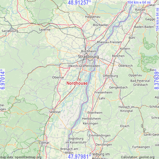
Nordhouse GPS coordinates[2]
48° 26' 53.988" North, 7° 40' 23.736" East
| Map corner | latitude | longitude |
|---|---|---|
| Upper-left | 48.91257°, | 6.97014° |
| Center: | 48.44833°, | 7.67326° |
| Lower-right: | 47.97981°, | 8.37639° |
| Map W x H: | 103.7×103.7 km | = 64.4×64.4mi |
| max Lat: | 51.07786° ⇑32.8% North |
| Nordhouse: | 48.44833° |
| min Lat: | ⇓67.2% South 41.3874° |
| min Long | Nordhouse | max Long |
| -5.08615° | 7.67326° | 9.52242° |
| W 98.9%⇐ | ⇒1.1% E |
Elevation
Elevation of Nordhouse is 153 m = 502 ft, and this is 40.7 m = 134 ft below average elevation for this country.
| Max E: |
2333 m = 7654 ft | 44.1% |
| Avg. | 193.7 m = 635 ft | |
| Nordhouse | 153 m = 502 ft | |
Min E: |
-1 m = -3 ft | 55.9% |
See also: France elevation on elevation.city.
Geographical zone
Nordhouse is located in North temperate zone (between Tropic of Cancer and the Arctic Circle). Distance of this North polar circle is 2014.2 km =1251.6 mi to North.| Distance of | km | miles | from Nordhouse |
|---|---|---|---|
| North Pole | 4620.1 | 2870.8 | to North |
| Arctic Circle | 2014.2 | 1251.6 | to North |
| Tropic Cancer | 2781 | 1728 | to South |
| Equator | 5386.9 | 3347.3 | to South |


Nearby cities:
15 places around Nordhouse: (largest is in red/bold)
• Blaesheim
8 km =5 mi,  323°
323°
• Erstein
2.8 km =1.7 mi,  196°
196°
• Eschau
5.5 km =3.4 mi,  35°
35°
• Fegersheim
4.7 km =2.9 mi,  7°
7°
• Geispolsheim
7.7 km =4.8 mi,  346°
346°
• Gerstheim
7.7 km =4.8 mi,  162°
162°
• Hindisheim
3.4 km =2.1 mi,  311°
311°
• Hipsheim
2.1 km =1.3 mi, 5°
• Limersheim
2.2 km =1.4 mi,  289°
289°
• Lipsheim
4.8 km =3 mi, 354°
• Matzenheim
7.1 km =4.4 mi,  212°
212°
• Osthouse
5.6 km =3.5 mi, 203°
• Plobsheim
4.5 km =2.8 mi,  57°
57°
• Schaeffersheim
4.4 km =2.7 mi,  238°
238°
• Uttenheim
7 km =4.3 mi,  233°
233°
Sources, notices
• [Note1] Compared only with cities in France existing in our database
• [Src1] Map data: © OpenStreetMap contributors (CC-BY-SA)
• [Src2] Other city data from geonames.org with taken over terms of usage.
• [Src3] Geographical zone / Annual Mean Temperature by Robert A. Rohde @ Wikipedia
