Plobsheim geodata
Plobsheim (Grand Est) is a populated place; located in France in Europe/Paris (GMT+2) time zone. With population of 3,829 people, there are 2570 cities with bigger population in this country. Compared to other cities in France, 67.7% of cities are located further ↓South; 99.1% of cities are located further ←West and 53.9% of cities have lower elevation than Plobsheim. Note1
Administrative division(s):
- Level 1: Grand Est
- Level 2: Bas-Rhin
- Level 3: Arrondissement de Strasbourg
- Level 4: Plobsheim


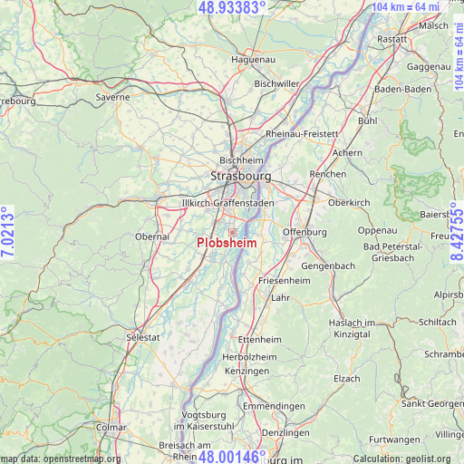
Plobsheim GPS coordinates[2]
48° 28' 11.244" North, 7° 43' 27.912" East
| Map corner | latitude | longitude |
|---|---|---|
| Upper-left | 48.93383°, | 7.0213° |
| Center: | 48.46979°, | 7.72442° |
| Lower-right: | 48.00146°, | 8.42755° |
| Map W x H: | 103.7×103.7 km | = 64.4×64.4mi |
| max Lat: | 51.07786° ⇑32.3% North |
| Plobsheim: | 48.46979° |
| min Lat: | ⇓67.7% South 41.3874° |
| min Long | Plobsheim | max Long |
| -5.08615° | 7.72442° | 9.52242° |
| W 99.1%⇐ | ⇒0.90000000000001% E |
Elevation
Elevation of Plobsheim is 146 m = 479 ft, and this is 47.7 m = 156 ft below average elevation for this country.
| Max E: |
2333 m = 7654 ft | 46.1% |
| Avg. | 193.7 m = 635 ft | |
| Plobsheim | 146 m = 479 ft | |
Min E: |
-1 m = -3 ft | 53.9% |
See also: France elevation on elevation.city.
Geographical zone
Plobsheim is located in North temperate zone (between Tropic of Cancer and the Arctic Circle). Distance of this North polar circle is 2011.8 km =1250.1 mi to North.| Distance of | km | miles | from Plobsheim |
|---|---|---|---|
| North Pole | 4617.7 | 2869.3 | to North |
| Arctic Circle | 2011.8 | 1250.1 | to North |
| Tropic Cancer | 2783.4 | 1729.5 | to South |
| Equator | 5389.3 | 3348.8 | to South |


Nearby cities:
15 places around Plobsheim: (largest is in red/bold)
• Blaesheim
9.4 km =5.8 mi,  295°
295°
• Entzheim
9.6 km =6 mi,  318°
318°
• Erstein
6.9 km =4.3 mi,  221°
221°
• Eschau
2.2 km =1.4 mi,  344°
344°
• Fegersheim
3.9 km =2.4 mi,  305°
305°
• Geispolsheim
7.6 km =4.7 mi, 312°
• Hindisheim
6.3 km =3.9 mi,  268°
268°
• Hipsheim
3.6 km =2.2 mi,  264°
264°
• Illkirch-Graffenstaden
6.6 km =4.1 mi,  354°
354°
• Limersheim
6.1 km =3.8 mi,  254°
254°
• Lipsheim
4.8 km =3 mi, 300°
• Nordhouse
4.5 km =2.8 mi,  237°
237°
• Osthouse
9.6 km =6 mi, 218°
• Ostwald
8.3 km =5.2 mi, 353°
• Schaeffersheim
8.8 km =5.5 mi, 238°
Sources, notices
• [Note1] Compared only with cities in France existing in our database
• [Src1] Map data: © OpenStreetMap contributors (CC-BY-SA)
• [Src2] Other city data from geonames.org with taken over terms of usage.
• [Src3] Geographical zone / Annual Mean Temperature by Robert A. Rohde @ Wikipedia
