Pruniers geodata
Pruniers (Centre) is a populated place; located in France in Europe/Paris (GMT+2) time zone. With population of 536 people, there are 14480 cities with bigger population in this country. Compared to other cities in France, 57.3% of cities are located further ↑North; 56.4% of cities are located further →East and 58.9% of cities have lower elevation than Pruniers. Note1
Administrative division(s):
- Level 1: Centre
- Level 2: Département de l'Indre
- Level 3: Arrondissement d'Issoudun
- Level 4: Pruniers


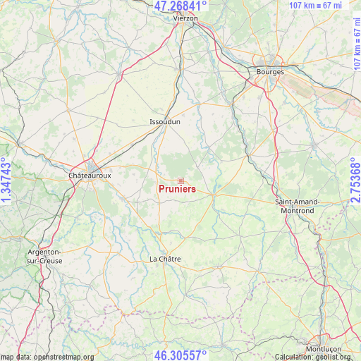
Pruniers GPS coordinates[2]
46° 47' 20.904" North, 2° 3' 2.016" East
| Map corner | latitude | longitude |
|---|---|---|
| Upper-left | 47.26841°, | 1.34743° |
| Center: | 46.78914°, | 2.05056° |
| Lower-right: | 46.30557°, | 2.75368° |
| Map W x H: | 107.1×107.1 km | = 66.5×66.5mi |
| max Lat: | 51.07786° ⇑57.3% North |
| Pruniers: | 46.78914° |
| min Lat: | ⇓42.7% South 41.3874° |
| min Long | Pruniers | max Long |
| -5.08615° | 2.05056° | 9.52242° |
| W 43.6%⇐ | ⇒56.4% E |
Elevation
Elevation of Pruniers is 165 m = 541 ft, and this is 28.7 m = 94 ft below average elevation for this country.
| Max E: |
2333 m = 7654 ft | 41.1% |
| Avg. | 193.7 m = 635 ft | |
| Pruniers | 165 m = 541 ft | |
Min E: |
-1 m = -3 ft | 58.9% |
See also: France elevation on elevation.city.
Geographical zone
Pruniers is located in North temperate zone (between Tropic of Cancer and the Arctic Circle). Distance of this North polar circle is 2198.7 km =1366.2 mi to North.| Distance of | km | miles | from Pruniers |
|---|---|---|---|
| North Pole | 4804.6 | 2985.4 | to North |
| Arctic Circle | 2198.7 | 1366.2 | to North |
| Tropic Cancer | 2596.5 | 1613.4 | to South |
| Equator | 5202.5 | 3232.7 | to South |


Nearby cities:
15 places around Pruniers: (largest is in red/bold)
• Ambrault
7 km =4.3 mi,  265°
265°
• Ardentes
17.3 km =10.7 mi,  252°
252°
• Chezal-Benoît
6.2 km =3.9 mi,  50°
50°
• Diors
17.5 km =10.9 mi,  284°
284°
• Issoudun
18.2 km =11.3 mi,  346°
346°
• Lignières
10.3 km =6.4 mi,  114°
114°
• Mareuil-sur-Arnon
13.2 km =8.2 mi,  39°
39°
• Mers-sur-Indre
19.4 km =12.1 mi,  221°
221°
• Montipouret
19.3 km =12 mi, 216°
• Mâron
14.4 km =8.9 mi, 278°
• Neuvy-Pailloux
17.9 km =11.1 mi,  306°
306°
• Saint-Août
9.1 km =5.7 mi,  225°
225°
• Saint-Chartier
16.5 km =10.3 mi,  199°
199°
• Saint-Hilaire-en-Lignières
11.7 km =7.3 mi,  126°
126°
• Étrechet
20.3 km =12.6 mi, 266°
Sources, notices
• [Note1] Compared only with cities in France existing in our database
• [Src1] Map data: © OpenStreetMap contributors (CC-BY-SA)
• [Src2] Other city data from geonames.org with taken over terms of usage.
• [Src3] Geographical zone / Annual Mean Temperature by Robert A. Rohde @ Wikipedia
