Millançay geodata
Millançay (Centre) is a populated place; located in France in Europe/Paris (GMT+2) time zone. With population of 697 people, there are 11838 cities with bigger population in this country. Compared to other cities in France, 50.5% of cities are located further ↓South; 59.7% of cities are located further →East and 58.7% of cities have higher elevation than Millançay. Note1
Administrative division(s):
- Level 1: Centre
- Level 2: Département du Loir-et-Cher
- Level 3: Arrondissement de Romorantin-Lanthenay
- Level 4: Millançay


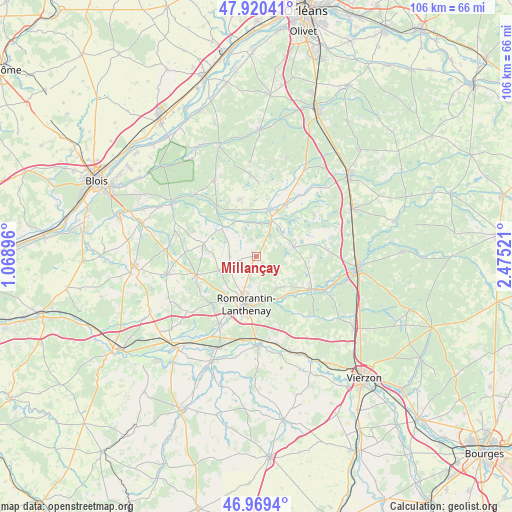
Millançay GPS coordinates[2]
47° 26' 49.38" North, 1° 46' 19.524" East
| Map corner | latitude | longitude |
|---|---|---|
| Upper-left | 47.92041°, | 1.06896° |
| Center: | 47.44705°, | 1.77209° |
| Lower-right: | 46.9694°, | 2.47521° |
| Map W x H: | 105.7×105.7 km | = 65.7×65.7mi |
| max Lat: | 51.07786° ⇑49.5% North |
| Millançay: | 47.44705° |
| min Lat: | ⇓50.5% South 41.3874° |
| min Long | Millançay | max Long |
| -5.08615° | 1.77209° | 9.52242° |
| W 40.3%⇐ | ⇒59.7% E |
Elevation
Elevation of Millançay is 106 m = 348 ft, and this is 87.7 m = 288 ft below average elevation for this country.
| Max E: |
2333 m = 7654 ft | 58.7% |
| Avg. | 193.7 m = 635 ft | |
| Millançay | 106 m = 348 ft | |
Min E: |
-1 m = -3 ft | 41.3% |
See also: France elevation on elevation.city.
Geographical zone
Millançay is located in North temperate zone (between Tropic of Cancer and the Arctic Circle). Distance of this North polar circle is 2125.6 km =1320.8 mi to North.| Distance of | km | miles | from Millançay |
|---|---|---|---|
| North Pole | 4731.4 | 2940 | to North |
| Arctic Circle | 2125.6 | 1320.8 | to North |
| Tropic Cancer | 2669.7 | 1658.9 | to South |
| Equator | 5275.6 | 3278.1 | to South |


Nearby cities:
15 places around Millançay: (largest is in red/bold)
• Dhuizon
17.8 km =11.1 mi,  331°
331°
• Fontaines-en-Sologne
18 km =11.2 mi,  292°
292°
• La Ferté-Beauharnais
12.1 km =7.5 mi,  29°
29°
• La Ferté-Imbault
15.3 km =9.5 mi,  116°
116°
• Marcilly-en-Gault
8 km =5 mi,  74°
74°
• Montrieux-en-Sologne
12.4 km =7.7 mi,  343°
343°
• Mur-de-Sologne
12.9 km =8 mi,  252°
252°
• Neung-sur-Beuvron
10.1 km =6.3 mi,  14°
14°
• Pruniers-en-Sologne
16.5 km =10.3 mi,  208°
208°
• Romorantin-Lanthenay
9.1 km =5.7 mi,  190°
190°
• Saint-Viâtre
14.8 km =9.2 mi,  54°
54°
• Selles-Saint-Denis
13.2 km =8.2 mi, 120°
• Vernou-en-Sologne
9.1 km =5.7 mi,  311°
311°
• Villefranche-sur-Cher
16.4 km =10.2 mi,  181°
181°
• Villeherviers
9.2 km =5.7 mi,  166°
166°
Sources, notices
• [Note1] Compared only with cities in France existing in our database
• [Src1] Map data: © OpenStreetMap contributors (CC-BY-SA)
• [Src2] Other city data from geonames.org with taken over terms of usage.
• [Src3] Geographical zone / Annual Mean Temperature by Robert A. Rohde @ Wikipedia
