Mur-de-Barrez geodata
Mur-de-Barrez (Occitanie) is a populated place; located in France in Europe/Paris (GMT+2) time zone. With population of 829 people, there are 10301 cities with bigger population in this country. Compared to other cities in France, 81% of cities are located further ↑North; 52.9% of cities are located further ←West and 97.7% of cities have lower elevation than Mur-de-Barrez. Note1
Administrative division(s):
- Level 1: Occitanie
- Level 2: Département de l'Aveyron
- Level 3: Arrondissement de Rodez
- Level 4: Mur-de-Barrez


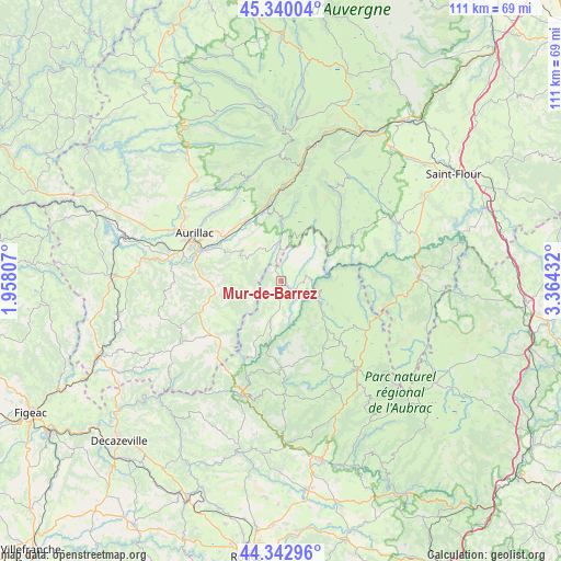
Mur-de-Barrez GPS coordinates[2]
44° 50' 37.176" North, 2° 39' 40.284" East
| Map corner | latitude | longitude |
|---|---|---|
| Upper-left | 45.34004°, | 1.95807° |
| Center: | 44.84366°, | 2.66119° |
| Lower-right: | 44.34296°, | 3.36432° |
| Map W x H: | 110.9×110.9 km | = 68.9×68.9mi |
| max Lat: | 51.07786° ⇑81% North |
| Mur-de-Barrez: | 44.84366° |
| min Lat: | ⇓19% South 41.3874° |
| min Long | Mur-de-Barrez | max Long |
| -5.08615° | 2.66119° | 9.52242° |
| W 52.9%⇐ | ⇒47.1% E |
Elevation
Elevation of Mur-de-Barrez is 792 m = 2598 ft, and this is 598.3 m = 1963 ft above average elevation for this country.
| Max E: |
2333 m = 7654 ft | 2.3% |
| Mur-de-Barrez | 792 m 2598 ft | |
| Avg. | 193.7 m = 635 ft | |
Min E: |
-1 m = -3 ft | 97.7% |
See also: France elevation on elevation.city.
Geographical zone
Mur-de-Barrez is located in North temperate zone (between Tropic of Cancer and the Arctic Circle). Distance of this Northern Tropic circle is 2380.2 km =1479 mi to South.| Distance of | km | miles | from Mur-de-Barrez |
|---|---|---|---|
| North Pole | 5020.9 | 3119.8 | to North |
| Arctic Circle | 2415 | 1500.6 | to North |
| Tropic Cancer | 2380.2 | 1479 | to South |
| Equator | 4986.1 | 3098.2 | to South |


Nearby cities:
15 places around Mur-de-Barrez: (largest is in red/bold)
• Arpajon-sur-Cère
17.5 km =10.9 mi,  292°
292°
• Aurillac
19.7 km =12.2 mi,  297°
297°
• Brommat
2.5 km =1.6 mi,  131°
131°
• Giou-de-Mamou
15.2 km =9.4 mi,  310°
310°
• Lacroix-Barrez
7.3 km =4.5 mi,  194°
194°
• Lafeuillade-en-Vézie
17 km =10.6 mi,  249°
249°
• Pierrefort
16.4 km =10.2 mi,  58°
58°
• Polminhac
13.7 km =8.5 mi,  331°
331°
• Prunet
15.8 km =9.8 mi,  260°
260°
• Saint-Amans-des-Cots
17.4 km =10.8 mi,  179°
179°
• Saint-Simon
18.9 km =11.7 mi, 314°
• Sainte-Geneviève-sur-Argence
9 km =5.6 mi,  120°
120°
• Taussac
2.2 km =1.4 mi,  222°
222°
• Thiézac
19 km =11.8 mi,  0°
0°
• Vic-sur-Cère
15.4 km =9.6 mi,  349°
349°
Sources, notices
• [Note1] Compared only with cities in France existing in our database
• [Src1] Map data: © OpenStreetMap contributors (CC-BY-SA)
• [Src2] Other city data from geonames.org with taken over terms of usage.
• [Src3] Geographical zone / Annual Mean Temperature by Robert A. Rohde @ Wikipedia
