Monthureux-sur-Saône geodata
Monthureux-sur-Saône (Grand Est) is a populated place; located in France in Europe/Paris (GMT+2) time zone. With population of 952 people, there are 9192 cities with bigger population in this country. Compared to other cities in France, 59.9% of cities are located further ↓South; 86.8% of cities are located further ←West and 75.1% of cities have lower elevation than Monthureux-sur-Saône. Note1
Administrative division(s):
- Level 1: Grand Est
- Level 2: Vosges
- Level 3: Arrondissement de Neufchâteau
- Level 4: Monthureux-sur-Saône


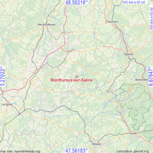
Monthureux-sur-Saône GPS coordinates[2]
48° 2' 2.94" North, 5° 58' 24.024" East
| Map corner | latitude | longitude |
|---|---|---|
| Upper-left | 48.50218°, | 5.27022° |
| Center: | 48.03415°, | 5.97334° |
| Lower-right: | 47.56183°, | 6.67647° |
| Map W x H: | 104.6×104.6 km | = 65×65mi |
| max Lat: | 51.07786° ⇑40.1% North |
| Monthureux-sur-Saône: | 48.03415° |
| min Lat: | ⇓59.9% South 41.3874° |
| min Long | Monthureux-sur- | max Long |
| -5.08615° | 5.97334° | 9.52242° |
| W 86.8%⇐ | ⇒13.2% E |
Elevation
Elevation of Monthureux-sur-Saône is 250 m = 820 ft, and this is 56.3 m = 185 ft above average elevation for this country.
| Max E: |
2333 m = 7654 ft | 24.9% |
| Monthureux-sur-Saône | 250 m 820 ft | |
| Avg. | 193.7 m = 635 ft | |
Min E: |
-1 m = -3 ft | 75.1% |
See also: France elevation on elevation.city.
Geographical zone
Monthureux-sur-Saône is located in North temperate zone (between Tropic of Cancer and the Arctic Circle). Distance of this North polar circle is 2060.3 km =1280.2 mi to North.| Distance of | km | miles | from Monthureux-sur-Saône |
|---|---|---|---|
| North Pole | 4666.2 | 2899.4 | to North |
| Arctic Circle | 2060.3 | 1280.2 | to North |
| Tropic Cancer | 2735 | 1699.4 | to South |
| Equator | 5340.9 | 3318.7 | to South |


Nearby cities:
15 places around Monthureux-sur-Saône: (largest is in red/bold)
• Bains-les-Bains
22 km =13.7 mi,  99°
99°
• Bourbonne-les-Bains
19 km =11.8 mi,  241°
241°
• Bulgnéville
21.8 km =13.5 mi,  331°
331°
• Contrexéville
17.7 km =11 mi,  340°
340°
• Corre
12.9 km =8 mi,  173°
173°
• Darney
8.1 km =5 mi,  44°
44°
• Fontenoy-le-Château
18.1 km =11.2 mi,  111°
111°
• Jussey
23.8 km =14.8 mi,  192°
192°
• Lamarche
14.8 km =9.2 mi,  285°
285°
• Martigny-les-Bains
13.6 km =8.5 mi,  305°
305°
• Passavant-la-Rochère
8.7 km =5.4 mi,  147°
147°
• Polaincourt-et-Clairefontaine
18.4 km =11.4 mi,  157°
157°
• Remoncourt
22.5 km =14 mi,  14°
14°
• Vauvillers
15.6 km =9.7 mi,  143°
143°
• Vittel
18.6 km =11.6 mi,  354°
354°
Sources, notices
• [Note1] Compared only with cities in France existing in our database
• [Src1] Map data: © OpenStreetMap contributors (CC-BY-SA)
• [Src2] Other city data from geonames.org with taken over terms of usage.
• [Src3] Geographical zone / Annual Mean Temperature by Robert A. Rohde @ Wikipedia
