Montgermont geodata
Montgermont (Brittany) is a populated place; located in France in Europe/Paris (GMT+2) time zone. With population of 3,012 people, there are 3240 cities with bigger population in this country. Compared to other cities in France, 62.1% of cities are located further ↓South; 93.6% of cities are located further →East and 80.2% of cities have higher elevation than Montgermont. Note1
Administrative division(s):
- Level 1: Brittany
- Level 2: Département d'Ille-et-Vilaine
- Level 3: Arrondissement de Rennes
- Level 4: Montgermont


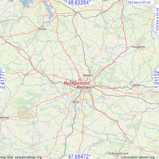
Montgermont GPS coordinates[2]
48° 9' 21.312" North, 1° 42' 52.704" West
| Map corner | latitude | longitude |
|---|---|---|
| Upper-left | 48.62284°, | -2.41777° |
| Center: | 48.15592°, | -1.71464° |
| Lower-right: | 47.68472°, | -1.01152° |
| Map W x H: | 104.3×104.3 km | = 64.8×64.8mi |
| max Lat: | 51.07786° ⇑37.9% North |
| Montgermont: | 48.15592° |
| min Lat: | ⇓62.1% South 41.3874° |
| min Long | Montgermont | max Long |
| -5.08615° | -1.71464° | 9.52242° |
| W 6.4%⇐ | ⇒93.6% E |
Elevation
Elevation of Montgermont is 54 m = 177 ft, and this is 139.7 m = 458 ft below average elevation for this country.
| Max E: |
2333 m = 7654 ft | 80.2% |
| Avg. | 193.7 m = 635 ft | |
| Montgermont | 54 m = 177 ft | |
Min E: |
-1 m = -3 ft | 19.8% |
See also: France elevation on elevation.city.
Geographical zone
Montgermont is located in North temperate zone (between Tropic of Cancer and the Arctic Circle). Distance of this North polar circle is 2046.7 km =1271.8 mi to North.| Distance of | km | miles | from Montgermont |
|---|---|---|---|
| North Pole | 4652.6 | 2891 | to North |
| Arctic Circle | 2046.7 | 1271.8 | to North |
| Tropic Cancer | 2748.5 | 1707.8 | to South |
| Equator | 5354.4 | 3327.1 | to South |


Nearby cities:
15 places around Montgermont: (largest is in red/bold)
• Betton
6.3 km =3.9 mi,  64°
64°
• Cesson-Sévigné
9.1 km =5.7 mi,  114°
114°
• Chevaigné
8.8 km =5.5 mi,  45°
45°
• Fouillard
10.1 km =6.3 mi,  88°
88°
• Gévezé
9 km =5.6 mi,  321°
321°
• La Chapelle-des-Fougeretz
2.7 km =1.7 mi,  332°
332°
• La Mézière
7.6 km =4.7 mi,  336°
336°
• Le Rheu
8.6 km =5.3 mi,  225°
225°
• Melesse
7 km =4.3 mi,  11°
11°
• Pacé
4.4 km =2.7 mi,  259°
259°
• Parthenay-de-Bretagne
9.4 km =5.8 mi,  295°
295°
• Rennes
5.7 km =3.5 mi,  148°
148°
• Saint-Gilles
8.2 km =5.1 mi,  268°
268°
• Saint-Grégoire
2.1 km =1.3 mi, 105°
• Vezin-le-Coquet
5.1 km =3.2 mi,  215°
215°
Sources, notices
• [Note1] Compared only with cities in France existing in our database
• [Src1] Map data: © OpenStreetMap contributors (CC-BY-SA)
• [Src2] Other city data from geonames.org with taken over terms of usage.
• [Src3] Geographical zone / Annual Mean Temperature by Robert A. Rohde @ Wikipedia
