Betton geodata
Betton (Brittany) is a populated place; located in France in Europe/Paris (GMT+2) time zone. With population of 9,343 people, there are 1026 cities with bigger population in this country. Compared to other cities in France, 62.5% of cities are located further ↓South; 93.2% of cities are located further →East and 87.1% of cities have higher elevation than Betton. Note1
Administrative division(s):
- Level 1: Brittany
- Level 2: Département d'Ille-et-Vilaine
- Level 3: Arrondissement de Rennes
- Level 4: Betton


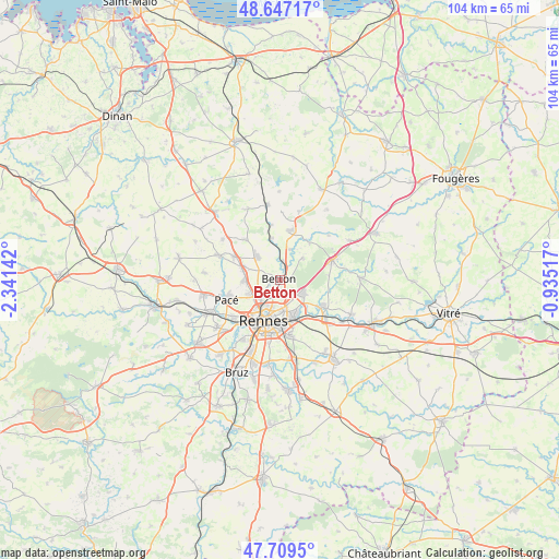
Betton GPS coordinates[2]
48° 10' 49.728" North, 1° 38' 17.844" West
| Map corner | latitude | longitude |
|---|---|---|
| Upper-left | 48.64717°, | -2.34142° |
| Center: | 48.18048°, | -1.63829° |
| Lower-right: | 47.7095°, | -0.93517° |
| Map W x H: | 104.3×104.3 km | = 64.8×64.8mi |
| max Lat: | 51.07786° ⇑37.5% North |
| Betton: | 48.18048° |
| min Lat: | ⇓62.5% South 41.3874° |
| min Long | Betton | max Long |
| -5.08615° | -1.63829° | 9.52242° |
| W 6.8%⇐ | ⇒93.2% E |
Elevation
Elevation of Betton is 37 m = 121 ft, and this is 156.7 m = 514 ft below average elevation for this country.
| Max E: |
2333 m = 7654 ft | 87.1% |
| Avg. | 193.7 m = 635 ft | |
| Betton | 37 m = 121 ft | |
Min E: |
-1 m = -3 ft | 12.9% |
See also: France elevation on elevation.city.
Geographical zone
Betton is located in North temperate zone (between Tropic of Cancer and the Arctic Circle). Distance of this North polar circle is 2044 km =1270.1 mi to North.| Distance of | km | miles | from Betton |
|---|---|---|---|
| North Pole | 4649.9 | 2889.3 | to North |
| Arctic Circle | 2044 | 1270.1 | to North |
| Tropic Cancer | 2751.2 | 1709.5 | to South |
| Equator | 5357.2 | 3328.8 | to South |


Nearby cities:
15 places around Betton: (largest is in red/bold)
• Acigné
9.2 km =5.7 mi,  124°
124°
• Cesson-Sévigné
7.1 km =4.4 mi,  158°
158°
• Chasné-sur-Illet
8.9 km =5.5 mi,  39°
39°
• Chevaigné
3.5 km =2.2 mi,  10°
10°
• Fouillard
5 km =3.1 mi, 119°
• La Chapelle-des-Fougeretz
6.9 km =4.3 mi,  266°
266°
• La Mézière
9.6 km =6 mi,  295°
295°
• Melesse
5.9 km =3.7 mi,  314°
314°
• Montgermont
6.3 km =3.9 mi,  244°
244°
• Montreuil-le-Gast
9.8 km =6.1 mi,  318°
318°
• Mouazé
6.1 km =3.8 mi,  20°
20°
• Rennes
8.1 km =5 mi,  199°
199°
• Saint-Germain-sur-Ille
7.8 km =4.8 mi,  348°
348°
• Saint-Grégoire
4.9 km =3 mi,  227°
227°
• Saint-Sulpice-la-Forêt
5.9 km =3.7 mi,  47°
47°
Sources, notices
• [Note1] Compared only with cities in France existing in our database
• [Src1] Map data: © OpenStreetMap contributors (CC-BY-SA)
• [Src2] Other city data from geonames.org with taken over terms of usage.
• [Src3] Geographical zone / Annual Mean Temperature by Robert A. Rohde @ Wikipedia
