Montbard geodata
Montbard (Bourgogne-Franche-Comté) is a seat of a third-order administrative division; located in France in Europe/Paris (GMT+2) time zone. With population of 5,737 people, there are 1724 cities with bigger population in this country. Compared to other cities in France, 53% of cities are located further ↓South; 70.9% of cities are located further ←West and 69% of cities have lower elevation than Montbard. Note1
Administrative division(s):
- Level 1: Bourgogne-Franche-Comté
- Level 2: Département de la Côte-d'Or
- Level 3: Arrondissement de Montbard
- Level 4: Montbard


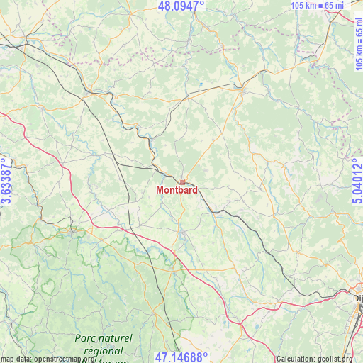
Montbard GPS coordinates[2]
47° 37' 22.584" North, 4° 20' 13.2" East
| Map corner | latitude | longitude |
|---|---|---|
| Upper-left | 48.0947°, | 3.63387° |
| Center: | 47.62294°, | 4.337° |
| Lower-right: | 47.14688°, | 5.04012° |
| Map W x H: | 105.4×105.4 km | = 65.5×65.5mi |
| max Lat: | 51.07786° ⇑47% North |
| Montbard: | 47.62294° |
| min Lat: | ⇓53% South 41.3874° |
| min Long | Montbard | max Long |
| -5.08615° | 4.337° | 9.52242° |
| W 70.9%⇐ | ⇒29.1% E |
Elevation
Elevation of Montbard is 214 m = 702 ft, and this is 20.3 m = 67 ft above average elevation for this country.
| Max E: |
2333 m = 7654 ft | 31% |
| Montbard | 214 m 702 ft | |
| Avg. | 193.7 m = 635 ft | |
Min E: |
-1 m = -3 ft | 69% |
See also: France elevation on elevation.city.
Geographical zone
Montbard is located in North temperate zone (between Tropic of Cancer and the Arctic Circle). Distance of this North polar circle is 2106 km =1308.6 mi to North.| Distance of | km | miles | from Montbard |
|---|---|---|---|
| North Pole | 4711.9 | 2927.8 | to North |
| Arctic Circle | 2106 | 1308.6 | to North |
| Tropic Cancer | 2689.3 | 1671.1 | to South |
| Equator | 5295.2 | 3290.3 | to South |


Nearby cities:
15 places around Montbard: (largest is in red/bold)
• Alise-Sainte-Reine
14.6 km =9.1 mi,  130°
130°
• Ancy-le-Franc
21.4 km =13.3 mi,  322°
322°
• La Roche-en-Brenil
29.4 km =18.3 mi,  203°
203°
• Laignes
24.5 km =15.2 mi,  4°
4°
• Lézinnes
27.2 km =16.9 mi, 316°
• Noyers
26.9 km =16.7 mi,  287°
287°
• Pouillenay
16.2 km =10.1 mi,  142°
142°
• Précy-sous-Thil
26 km =16.2 mi,  184°
184°
• Ravières
14.9 km =9.3 mi,  326°
326°
• Rouvray
28.1 km =17.5 mi,  218°
218°
• Saint-Rémy
3.4 km =2.1 mi,  298°
298°
• Semur-en-Auxois
15.5 km =9.6 mi, 181°
• Venarey-les-Laumes
12.9 km =8 mi, 134°
• Vitteaux
29.4 km =18.3 mi,  148°
148°
• Époisses
17.8 km =11.1 mi, 223°
Sources, notices
• [Note1] Compared only with cities in France existing in our database
• [Src1] Map data: © OpenStreetMap contributors (CC-BY-SA)
• [Src2] Other city data from geonames.org with taken over terms of usage.
• [Src3] Geographical zone / Annual Mean Temperature by Robert A. Rohde @ Wikipedia
