Montech geodata
Montech (Occitanie) is a populated place; located in France in Europe/Paris (GMT+2) time zone. With population of 3,743 people, there are 2625 cities with bigger population in this country. Compared to other cities in France, 87.5% of cities are located further ↑North; 66.4% of cities are located further →East and 57.3% of cities have higher elevation than Montech. Note1
Administrative division(s):
- Level 1: Occitanie
- Level 2: Département du Tarn-et-Garonne
- Level 3: Arrondissement de Montauban
- Level 4: Montech


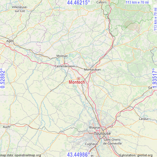
Montech GPS coordinates[2]
43° 57' 29.376" North, 1° 13' 55.344" East
| Map corner | latitude | longitude |
|---|---|---|
| Upper-left | 44.46215°, | 0.52892° |
| Center: | 43.95816°, | 1.23204° |
| Lower-right: | 43.44986°, | 1.93517° |
| Map W x H: | 112.6×112.6 km | = 70×70mi |
| max Lat: | 51.07786° ⇑87.5% North |
| Montech: | 43.95816° |
| min Lat: | ⇓12.5% South 41.3874° |
| min Long | Montech | max Long |
| -5.08615° | 1.23204° | 9.52242° |
| W 33.6%⇐ | ⇒66.4% E |
Elevation
Elevation of Montech is 110 m = 361 ft, and this is 83.7 m = 275 ft below average elevation for this country.
| Max E: |
2333 m = 7654 ft | 57.3% |
| Avg. | 193.7 m = 635 ft | |
| Montech | 110 m = 361 ft | |
Min E: |
-1 m = -3 ft | 42.7% |
See also: France elevation on elevation.city.
Geographical zone
Montech is located in North temperate zone (between Tropic of Cancer and the Arctic Circle). Distance of this Northern Tropic circle is 2281.8 km =1417.8 mi to South.| Distance of | km | miles | from Montech |
|---|---|---|---|
| North Pole | 5119.4 | 3181 | to North |
| Arctic Circle | 2513.5 | 1561.8 | to North |
| Tropic Cancer | 2281.8 | 1417.8 | to South |
| Equator | 4887.7 | 3037.1 | to South |


Nearby cities:
15 places around Montech: (largest is in red/bold)
• Albefeuille-Lagarde
10.3 km =6.4 mi,  13°
13°
• Bessens
9 km =5.6 mi,  168°
168°
• Bourret
5.4 km =3.4 mi,  251°
251°
• Bressols
8.6 km =5.3 mi,  82°
82°
• Campsas
10.3 km =6.4 mi,  132°
132°
• Corbarieu
11.1 km =6.9 mi,  98°
98°
• Dieupentale
11.1 km =6.9 mi,  164°
164°
• Escatalens
4.5 km =2.8 mi,  310°
310°
• Finhan
5.1 km =3.2 mi,  189°
189°
• Lacourt-Saint-Pierre
4 km =2.5 mi,  40°
40°
• Mas-Grenier
7.9 km =4.9 mi,  201°
201°
• Montbartier
6 km =3.7 mi,  145°
145°
• Montbeton
8.5 km =5.3 mi, 39°
• Saint-Porquier
6.6 km =4.1 mi,  320°
320°
• Saint-Sardos
10.2 km =6.3 mi,  230°
230°
Sources, notices
• [Note1] Compared only with cities in France existing in our database
• [Src1] Map data: © OpenStreetMap contributors (CC-BY-SA)
• [Src2] Other city data from geonames.org with taken over terms of usage.
• [Src3] Geographical zone / Annual Mean Temperature by Robert A. Rohde @ Wikipedia
