Moissac geodata
Moissac (Occitanie) is a populated place; located in France in Europe/Paris (GMT+2) time zone. With population of 13,703 people, there are 696 cities with bigger population in this country. Compared to other cities in France, 86.2% of cities are located further ↑North; 67.9% of cities are located further →East and 73.1% of cities have higher elevation than Moissac. Note1
Administrative division(s):
- Level 1: Occitanie
- Level 2: Département du Tarn-et-Garonne
- Level 3: Arrondissement de Castelsarrasin
- Level 4: Moissac


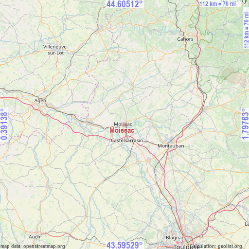
Moissac GPS coordinates[2]
44° 6' 8.496" North, 1° 5' 40.2" East
| Map corner | latitude | longitude |
|---|---|---|
| Upper-left | 44.60512°, | 0.39138° |
| Center: | 44.10236°, | 1.0945° |
| Lower-right: | 43.59529°, | 1.79763° |
| Map W x H: | 112.3×112.3 km | = 69.8×69.8mi |
| max Lat: | 51.07786° ⇑86.2% North |
| Moissac: | 44.10236° |
| min Lat: | ⇓13.8% South 41.3874° |
| min Long | Moissac | max Long |
| -5.08615° | 1.0945° | 9.52242° |
| W 32.1%⇐ | ⇒67.9% E |
Elevation
Elevation of Moissac is 71 m = 233 ft, and this is 122.7 m = 403 ft below average elevation for this country.
| Max E: |
2333 m = 7654 ft | 73.1% |
| Avg. | 193.7 m = 635 ft | |
| Moissac | 71 m = 233 ft | |
Min E: |
-1 m = -3 ft | 26.9% |
See also: France elevation on elevation.city.
Geographical zone
Moissac is located in North temperate zone (between Tropic of Cancer and the Arctic Circle). Distance of this Northern Tropic circle is 2297.8 km =1427.8 mi to South.| Distance of | km | miles | from Moissac |
|---|---|---|---|
| North Pole | 5103.3 | 3171 | to North |
| Arctic Circle | 2497.5 | 1551.9 | to North |
| Tropic Cancer | 2297.8 | 1427.8 | to South |
| Equator | 4903.7 | 3047 | to South |


Nearby cities:
15 places around Moissac: (largest is in red/bold)
• Albefeuille-Lagarde
14.7 km =9.1 mi,  114°
114°
• Boudou
6.5 km =4 mi,  263°
263°
• Castelmayran
9.2 km =5.7 mi,  208°
208°
• Castelsagrat
14.9 km =9.3 mi,  307°
307°
• Castelsarrasin
7 km =4.3 mi,  171°
171°
• Durfort-Lacapelette
9.5 km =5.9 mi,  18°
18°
• Garganvillar
13.9 km =8.6 mi,  188°
188°
• Goudourville
13.3 km =8.3 mi,  275°
275°
• Labastide-du-Temple
8.3 km =5.2 mi,  103°
103°
• Lafrançaise
12.1 km =7.5 mi,  76°
76°
• Malause
9.9 km =6.2 mi, 262°
• Meauzac
11.7 km =7.3 mi, 97°
• Montesquieu
10.8 km =6.7 mi,  344°
344°
• Saint-Nicolas-de-la-Grave
7.1 km =4.4 mi,  233°
233°
• Saint-Porquier
12.9 km =8 mi,  148°
148°
Sources, notices
• [Note1] Compared only with cities in France existing in our database
• [Src1] Map data: © OpenStreetMap contributors (CC-BY-SA)
• [Src2] Other city data from geonames.org with taken over terms of usage.
• [Src3] Geographical zone / Annual Mean Temperature by Robert A. Rohde @ Wikipedia
