Garganvillar geodata
Garganvillar (Occitanie) is a populated place; located in France in Europe/Paris (GMT+2) time zone. With population of 540 people, there are 14387 cities with bigger population in this country. Compared to other cities in France, 87.3% of cities are located further ↑North; 68.1% of cities are located further →East and 59.1% of cities have lower elevation than Garganvillar. Note1
Administrative division(s):
- Level 1: Occitanie
- Level 2: Département du Tarn-et-Garonne
- Level 3: Arrondissement de Castelsarrasin
- Level 4: Garganvillar


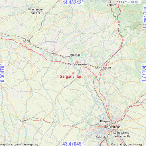
Garganvillar GPS coordinates[2]
43° 58' 42.996" North, 1° 4' 4.476" East
| Map corner | latitude | longitude |
|---|---|---|
| Upper-left | 44.48242°, | 0.36479° |
| Center: | 43.97861°, | 1.06791° |
| Lower-right: | 43.47049°, | 1.77104° |
| Map W x H: | 112.5×112.5 km | = 69.9×69.9mi |
| max Lat: | 51.07786° ⇑87.3% North |
| Garganvillar: | 43.97861° |
| min Lat: | ⇓12.7% South 41.3874° |
| min Long | Garganvillar | max Long |
| -5.08615° | 1.06791° | 9.52242° |
| W 31.9%⇐ | ⇒68.1% E |
Elevation
Elevation of Garganvillar is 166 m = 545 ft, and this is 27.7 m = 91 ft below average elevation for this country.
| Max E: |
2333 m = 7654 ft | 40.9% |
| Avg. | 193.7 m = 635 ft | |
| Garganvillar | 166 m = 545 ft | |
Min E: |
-1 m = -3 ft | 59.1% |
See also: France elevation on elevation.city.
Geographical zone
Garganvillar is located in North temperate zone (between Tropic of Cancer and the Arctic Circle). Distance of this Northern Tropic circle is 2284 km =1419.2 mi to South.| Distance of | km | miles | from Garganvillar |
|---|---|---|---|
| North Pole | 5117.1 | 3179.6 | to North |
| Arctic Circle | 2511.2 | 1560.4 | to North |
| Tropic Cancer | 2284 | 1419.2 | to South |
| Equator | 4890 | 3038.5 | to South |


Nearby cities:
15 places around Garganvillar: (largest is in red/bold)
• Beaumont-de-Lomagne
12.4 km =7.7 mi,  211°
211°
• Boudou
13.8 km =8.6 mi,  341°
341°
• Bourret
9 km =5.6 mi,  116°
116°
• Castelmayran
6.1 km =3.8 mi, 337°
• Castelsarrasin
7.5 km =4.7 mi,  24°
24°
• Escatalens
9.7 km =6 mi,  86°
86°
• Larrazet
5.4 km =3.4 mi,  166°
166°
• Lavit
12.1 km =7.5 mi,  258°
258°
• Mas-Grenier
14.1 km =8.8 mi,  133°
133°
• Moissac
13.9 km =8.6 mi,  8°
8°
• Montech
13.3 km =8.3 mi,  99°
99°
• Saint-Nicolas-de-la-Grave
10.2 km =6.3 mi, 339°
• Saint-Porquier
9.3 km =5.8 mi,  72°
72°
• Saint-Sardos
10.2 km =6.3 mi,  148°
148°
• Sérignac
7.3 km =4.5 mi, 211°
Sources, notices
• [Note1] Compared only with cities in France existing in our database
• [Src1] Map data: © OpenStreetMap contributors (CC-BY-SA)
• [Src2] Other city data from geonames.org with taken over terms of usage.
• [Src3] Geographical zone / Annual Mean Temperature by Robert A. Rohde @ Wikipedia
