Castelsarrasin geodata
Castelsarrasin (Occitanie) is a seat of a third-order administrative division; located in France in Europe/Paris (GMT+2) time zone. With population of 13,260 people, there are 717 cities with bigger population in this country. Compared to other cities in France, 86.8% of cities are located further ↑North; 67.8% of cities are located further →East and 68.3% of cities have higher elevation than Castelsarrasin. Note1
Administrative division(s):
- Level 1: Occitanie
- Level 2: Département du Tarn-et-Garonne
- Level 3: Arrondissement de Castelsarrasin
- Level 4: Castelsarrasin


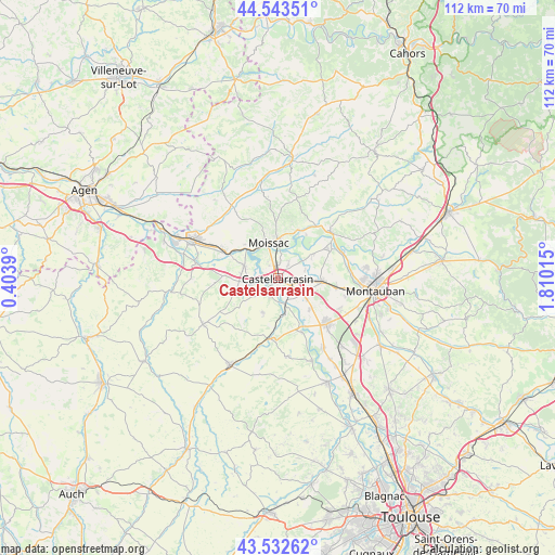
Castelsarrasin GPS coordinates[2]
44° 2' 24.792" North, 1° 6' 25.272" East
| Map corner | latitude | longitude |
|---|---|---|
| Upper-left | 44.54351°, | 0.4039° |
| Center: | 44.04022°, | 1.10702° |
| Lower-right: | 43.53262°, | 1.81015° |
| Map W x H: | 112.4×112.4 km | = 69.8×69.8mi |
| max Lat: | 51.07786° ⇑86.8% North |
| Castelsarrasin: | 44.04022° |
| min Lat: | ⇓13.2% South 41.3874° |
| min Long | Castelsarrasin | max Long |
| -5.08615° | 1.10702° | 9.52242° |
| W 32.2%⇐ | ⇒67.8% E |
Elevation
Elevation of Castelsarrasin is 82 m = 269 ft, and this is 111.7 m = 366 ft below average elevation for this country.
| Max E: |
2333 m = 7654 ft | 68.3% |
| Avg. | 193.7 m = 635 ft | |
| Castelsarrasin | 82 m = 269 ft | |
Min E: |
-1 m = -3 ft | 31.7% |
See also: France elevation on elevation.city.
Geographical zone
Castelsarrasin is located in North temperate zone (between Tropic of Cancer and the Arctic Circle). Distance of this Northern Tropic circle is 2290.9 km =1423.5 mi to South.| Distance of | km | miles | from Castelsarrasin |
|---|---|---|---|
| North Pole | 5110.2 | 3175.3 | to North |
| Arctic Circle | 2504.4 | 1556.2 | to North |
| Tropic Cancer | 2290.9 | 1423.5 | to South |
| Equator | 4896.8 | 3042.7 | to South |


Nearby cities:
15 places around Castelsarrasin: (largest is in red/bold)
• Albefeuille-Lagarde
12.4 km =7.7 mi,  86°
86°
• Boudou
9.7 km =6 mi,  309°
309°
• Bourret
11.9 km =7.4 mi,  155°
155°
• Castelmayran
5.6 km =3.5 mi,  257°
257°
• Escatalens
9 km =5.6 mi,  133°
133°
• Garganvillar
7.5 km =4.7 mi,  204°
204°
• Labastide-du-Temple
8.6 km =5.3 mi,  55°
55°
• Lacourt-Saint-Pierre
14 km =8.7 mi,  115°
115°
• Larrazet
12.3 km =7.6 mi,  188°
188°
• Malause
12.1 km =7.5 mi,  297°
297°
• Meauzac
11.9 km =7.4 mi, 63°
• Moissac
7 km =4.3 mi,  351°
351°
• Montech
13.5 km =8.4 mi, 132°
• Saint-Nicolas-de-la-Grave
7.2 km =4.5 mi,  291°
291°
• Saint-Porquier
7.1 km =4.4 mi, 125°
Sources, notices
• [Note1] Compared only with cities in France existing in our database
• [Src1] Map data: © OpenStreetMap contributors (CC-BY-SA)
• [Src2] Other city data from geonames.org with taken over terms of usage.
• [Src3] Geographical zone / Annual Mean Temperature by Robert A. Rohde @ Wikipedia
