Castelmayran geodata
Castelmayran (Occitanie) is a populated place; located in France in Europe/Paris (GMT+2) time zone. With population of 872 people, there are 9883 cities with bigger population in this country. Compared to other cities in France, 86.8% of cities are located further ↑North; 68.4% of cities are located further →East and 63.2% of cities have higher elevation than Castelmayran. Note1
Administrative division(s):
- Level 1: Occitanie
- Level 2: Département du Tarn-et-Garonne
- Level 3: Arrondissement de Castelsarrasin
- Level 4: Castelmayran


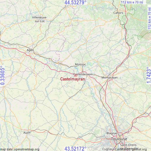
Castelmayran GPS coordinates[2]
44° 1' 45.876" North, 1° 2' 21.012" East
| Map corner | latitude | longitude |
|---|---|---|
| Upper-left | 44.53279°, | 0.33605° |
| Center: | 44.02941°, | 1.03917° |
| Lower-right: | 43.52172°, | 1.7423° |
| Map W x H: | 112.4×112.4 km | = 69.8×69.8mi |
| max Lat: | 51.07786° ⇑86.8% North |
| Castelmayran: | 44.02941° |
| min Lat: | ⇓13.2% South 41.3874° |
| min Long | Castelmayran | max Long |
| -5.08615° | 1.03917° | 9.52242° |
| W 31.6%⇐ | ⇒68.4% E |
Elevation
Elevation of Castelmayran is 94 m = 308 ft, and this is 99.7 m = 327 ft below average elevation for this country.
| Max E: |
2333 m = 7654 ft | 63.2% |
| Avg. | 193.7 m = 635 ft | |
| Castelmayran | 94 m = 308 ft | |
Min E: |
-1 m = -3 ft | 36.8% |
See also: France elevation on elevation.city.
Geographical zone
Castelmayran is located in North temperate zone (between Tropic of Cancer and the Arctic Circle). Distance of this Northern Tropic circle is 2289.7 km =1422.8 mi to South.| Distance of | km | miles | from Castelmayran |
|---|---|---|---|
| North Pole | 5111.5 | 3176.1 | to North |
| Arctic Circle | 2505.6 | 1556.9 | to North |
| Tropic Cancer | 2289.7 | 1422.8 | to South |
| Equator | 4895.6 | 3042 | to South |


Nearby cities:
15 places around Castelmayran: (largest is in red/bold)
• Auvillar
11.8 km =7.3 mi,  291°
291°
• Boudou
7.7 km =4.8 mi,  344°
344°
• Bourret
14.1 km =8.8 mi,  133°
133°
• Castelsarrasin
5.6 km =3.5 mi,  77°
77°
• Escatalens
13 km =8.1 mi,  112°
112°
• Garganvillar
6.1 km =3.8 mi,  157°
157°
• Goudourville
12.9 km =8 mi,  316°
316°
• Labastide-du-Temple
13.9 km =8.6 mi,  63°
63°
• Larrazet
11.5 km =7.1 mi, 162°
• Lavit
12.5 km =7.8 mi,  229°
229°
• Malause
8.7 km =5.4 mi, 321°
• Moissac
9.2 km =5.7 mi,  28°
28°
• Saint-Nicolas-de-la-Grave
4.1 km =2.5 mi, 341°
• Saint-Porquier
11.6 km =7.2 mi,  104°
104°
• Sérignac
11.9 km =7.4 mi,  187°
187°
Sources, notices
• [Note1] Compared only with cities in France existing in our database
• [Src1] Map data: © OpenStreetMap contributors (CC-BY-SA)
• [Src2] Other city data from geonames.org with taken over terms of usage.
• [Src3] Geographical zone / Annual Mean Temperature by Robert A. Rohde @ Wikipedia
