La Cavalerie geodata
La Cavalerie (Occitanie) is a populated place; located in France in Europe/Paris (GMT+2) time zone. With population of 1,048 people, there are 8479 cities with bigger population in this country. Compared to other cities in France, 87% of cities are located further ↑North; 60% of cities are located further ←West and 97.7% of cities have lower elevation than La Cavalerie. Note1
Administrative division(s):
- Level 1: Occitanie
- Level 2: Département de l'Aveyron
- Level 3: Arrondissement de Millau
- Level 4: La Cavalerie


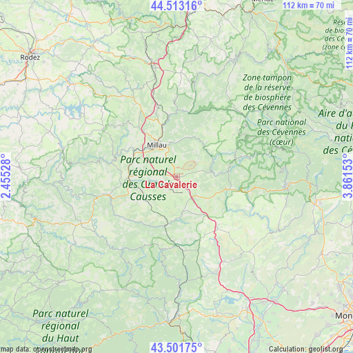
La Cavalerie GPS coordinates[2]
44° 0' 34.596" North, 3° 9' 30.24" East
| Map corner | latitude | longitude |
|---|---|---|
| Upper-left | 44.51316°, | 2.45528° |
| Center: | 44.00961°, | 3.1584° |
| Lower-right: | 43.50175°, | 3.86153° |
| Map W x H: | 112.5×112.5 km | = 69.9×69.9mi |
| max Lat: | 51.07786° ⇑87% North |
| La Cavalerie: | 44.00961° |
| min Lat: | ⇓13% South 41.3874° |
| min Long | La Cavalerie | max Long |
| -5.08615° | 3.1584° | 9.52242° |
| W 60%⇐ | ⇒40% E |
Elevation
Elevation of La Cavalerie is 794 m = 2605 ft, and this is 600.3 m = 1969 ft above average elevation for this country.
| Max E: |
2333 m = 7654 ft | 2.3% |
| La Cavalerie | 794 m 2605 ft | |
| Avg. | 193.7 m = 635 ft | |
Min E: |
-1 m = -3 ft | 97.7% |
See also: France elevation on elevation.city.
Geographical zone
La Cavalerie is located in North temperate zone (between Tropic of Cancer and the Arctic Circle). Distance of this Northern Tropic circle is 2287.5 km =1421.4 mi to South.| Distance of | km | miles | from La Cavalerie |
|---|---|---|---|
| North Pole | 5113.7 | 3177.5 | to North |
| Arctic Circle | 2507.8 | 1558.3 | to North |
| Tropic Cancer | 2287.5 | 1421.4 | to South |
| Equator | 4893.4 | 3040.6 | to South |


Nearby cities:
15 places around La Cavalerie: (largest is in red/bold)
• Aguessac
17 km =10.6 mi,  343°
343°
• Compeyre
17.4 km =10.8 mi,  345°
345°
• Creissels
11.5 km =7.1 mi,  317°
317°
• Meyrueis
28.7 km =17.8 mi,  49°
49°
• Millau
11.7 km =7.3 mi,  326°
326°
• Nant
11.6 km =7.2 mi,  83°
83°
• Rivière-sur-Tarn
20.1 km =12.5 mi, 353°
• Roquefort-sur-Soulzon
13.9 km =8.6 mi,  254°
254°
• Saint-Affrique
22.4 km =13.9 mi, 254°
• Saint-Beauzély
23.6 km =14.7 mi, 317°
• Saint-Georges-de-Luzençon
15.1 km =9.4 mi,  293°
293°
• Saint-Jean-du-Bruel
16.3 km =10.1 mi,  85°
85°
• Saint-Rome-de-Cernon
15.5 km =9.6 mi,  271°
271°
• Saint-Rome-de-Tarn
21.4 km =13.3 mi,  281°
281°
• Viala-du-Tarn
23.4 km =14.5 mi, 287°
Sources, notices
• [Note1] Compared only with cities in France existing in our database
• [Src1] Map data: © OpenStreetMap contributors (CC-BY-SA)
• [Src2] Other city data from geonames.org with taken over terms of usage.
• [Src3] Geographical zone / Annual Mean Temperature by Robert A. Rohde @ Wikipedia
