Guipry geodata
Guipry (Brittany) is a populated place; located in France in Europe/Paris (GMT+2) time zone. With population of 3,281 people, there are 2970 cities with bigger population in this country. Compared to other cities in France, 56.2% of cities are located further ↓South; 94.2% of cities are located further →East and 84.5% of cities have higher elevation than Guipry. Note1
Administrative division(s):
- Level 1: Brittany
- Level 2: Département d'Ille-et-Vilaine
- Level 3: Arrondissement de Redon
- Level 4: Guipry-Messac


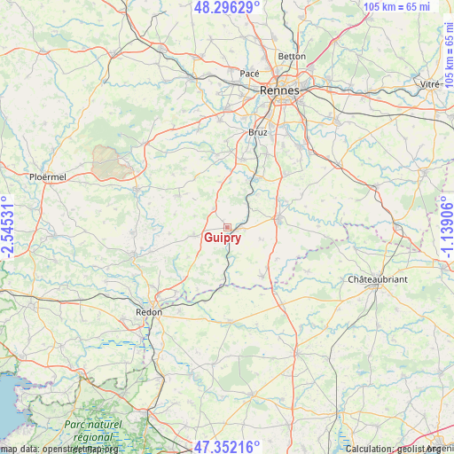
Guipry GPS coordinates[2]
47° 49' 34.932" North, 1° 50' 31.848" West
| Map corner | latitude | longitude |
|---|---|---|
| Upper-left | 48.29629°, | -2.54531° |
| Center: | 47.82637°, | -1.84218° |
| Lower-right: | 47.35216°, | -1.13906° |
| Map W x H: | 105×105 km | = 65.2×65.2mi |
| max Lat: | 51.07786° ⇑43.8% North |
| Guipry: | 47.82637° |
| min Lat: | ⇓56.2% South 41.3874° |
| min Long | Guipry | max Long |
| -5.08615° | -1.84218° | 9.52242° |
| W 5.8%⇐ | ⇒94.2% E |
Elevation
Elevation of Guipry is 43 m = 141 ft, and this is 150.7 m = 494 ft below average elevation for this country.
| Max E: |
2333 m = 7654 ft | 84.5% |
| Avg. | 193.7 m = 635 ft | |
| Guipry | 43 m = 141 ft | |
Min E: |
-1 m = -3 ft | 15.5% |
See also: France elevation on elevation.city.
Geographical zone
Guipry is located in North temperate zone (between Tropic of Cancer and the Arctic Circle). Distance of this North polar circle is 2083.4 km =1294.6 mi to North.| Distance of | km | miles | from Guipry |
|---|---|---|---|
| North Pole | 4689.3 | 2913.8 | to North |
| Arctic Circle | 2083.4 | 1294.6 | to North |
| Tropic Cancer | 2711.9 | 1685.1 | to South |
| Equator | 5317.8 | 3304.3 | to South |


Nearby cities:
15 places around Guipry: (largest is in red/bold)
• Bain-de-Bretagne
11.9 km =7.4 mi,  80°
80°
• Bruc-sur-Aff
13.3 km =8.3 mi,  264°
264°
• Guignen
10.5 km =6.5 mi,  352°
352°
• La Noë-Blanche
7.9 km =4.9 mi,  108°
108°
• Langon
11.8 km =7.3 mi,  182°
182°
• Lieuron
8 km =5 mi,  290°
290°
• Lohéac
5.4 km =3.4 mi,  325°
325°
• Mernel
12.3 km =7.6 mi,  309°
309°
• Messac
2.4 km =1.5 mi,  96°
96°
• Pipriac
8 km =5 mi, 256°
• Pléchâtel
10.3 km =6.4 mi,  42°
42°
• Saint-Just
11.1 km =6.9 mi,  232°
232°
• Saint-Malo-de-Phily
6.9 km =4.3 mi, 35°
• Saint-Senoux
9.7 km =6 mi,  24°
24°
• Sainte-Anne-sur-Vilaine
10.8 km =6.7 mi,  173°
173°
Sources, notices
• [Note1] Compared only with cities in France existing in our database
• [Src1] Map data: © OpenStreetMap contributors (CC-BY-SA)
• [Src2] Other city data from geonames.org with taken over terms of usage.
• [Src3] Geographical zone / Annual Mean Temperature by Robert A. Rohde @ Wikipedia
