Longny-au-Perche geodata
Longny-au-Perche (Normandy) is a populated place; located in France in Europe/Paris (GMT+2) time zone. With population of 1,630 people, there are 5729 cities with bigger population in this country. Compared to other cities in France, 69.1% of cities are located further ↓South; 71% of cities are located further →East and 59.3% of cities have lower elevation than Longny-au-Perche. Note1
Administrative division(s):
- Level 1: Normandy
- Level 2: Département de l'Orne
- Level 3: Arrondissement de Mortagne-au-Perche
- Level 4: Longny les Villages


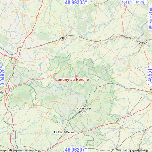
Longny-au-Perche GPS coordinates[2]
48° 31' 47.424" North, 0° 45' 8.604" East
| Map corner | latitude | longitude |
|---|---|---|
| Upper-left | 48.99333°, | 0.04926° |
| Center: | 48.52984°, | 0.75239° |
| Lower-right: | 48.06207°, | 1.45551° |
| Map W x H: | 103.5×103.5 km | = 64.3×64.3mi |
| max Lat: | 51.07786° ⇑30.9% North |
| Longny-au-Perche: | 48.52984° |
| min Lat: | ⇓69.1% South 41.3874° |
| min Long | Longny-au-Perch | max Long |
| -5.08615° | 0.75239° | 9.52242° |
| W 29%⇐ | ⇒71% E |
Elevation
Elevation of Longny-au-Perche is 167 m = 548 ft, and this is 26.7 m = 88 ft below average elevation for this country.
| Max E: |
2333 m = 7654 ft | 40.7% |
| Avg. | 193.7 m = 635 ft | |
| Longny-au-Perche | 167 m = 548 ft | |
Min E: |
-1 m = -3 ft | 59.3% |
See also: France elevation on elevation.city.
Geographical zone
Longny-au-Perche is located in North temperate zone (between Tropic of Cancer and the Arctic Circle). Distance of this North polar circle is 2005.2 km =1246 mi to North.| Distance of | km | miles | from Longny-au-Perche |
|---|---|---|---|
| North Pole | 4611 | 2865.1 | to North |
| Arctic Circle | 2005.2 | 1246 | to North |
| Tropic Cancer | 2790.1 | 1733.7 | to South |
| Equator | 5396 | 3352.9 | to South |


Nearby cities:
15 places around Longny-au-Perche: (largest is in red/bold)
• Bretoncelles
14.8 km =9.2 mi,  137°
137°
• La Chapelle-Montligeon
8.8 km =5.5 mi,  233°
233°
• La Ferté-Vidame
14.2 km =8.8 mi,  50°
50°
• Manou
16.8 km =10.4 mi,  93°
93°
• Mauves-sur-Huisne
13.1 km =8.1 mi, 227°
• Mortagne-au-Perche
15.1 km =9.4 mi,  265°
265°
• Moutiers-au-Perche
9.1 km =5.7 mi,  130°
130°
• Neuilly-sur-Eure
11.2 km =7 mi,  83°
83°
• Nocé
17.6 km =10.9 mi,  197°
197°
• Randonnai
14.4 km =8.9 mi,  336°
336°
• Rémalard
11.3 km =7 mi,  172°
172°
• Saint-Hilaire-le-Châtel
16.9 km =10.5 mi,  282°
282°
• Saint-Langis-lès-Mortagne
15 km =9.3 mi,  263°
263°
• Saint-Maurice-lès-Charencey
13.2 km =8.2 mi,  1°
1°
• Tourouvre
9.9 km =6.2 mi,  312°
312°
Sources, notices
• [Note1] Compared only with cities in France existing in our database
• [Src1] Map data: © OpenStreetMap contributors (CC-BY-SA)
• [Src2] Other city data from geonames.org with taken over terms of usage.
• [Src3] Geographical zone / Annual Mean Temperature by Robert A. Rohde @ Wikipedia
