Combs-la-Ville geodata
Combs-la-Ville (Île-de-France) is a populated place; located in France in Europe/Paris (GMT+2) time zone. With population of 22,322 people, there are 402 cities with bigger population in this country. Compared to other cities in France, 72.3% of cities are located further ↓South; 51.7% of cities are located further ←West and 68.7% of cities have higher elevation than Combs-la-Ville. Note1
Administrative division(s):
- Level 1: Île-de-France
- Level 2: Seine-et-Marne
- Level 3: Arrondissement de Melun
- Level 4: Combs-la-Ville


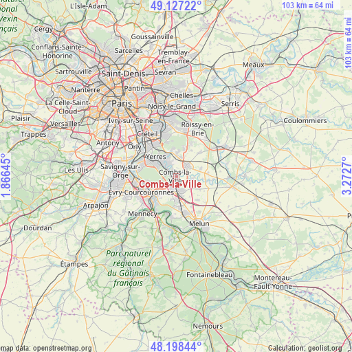
Combs-la-Ville GPS coordinates[2]
48° 39' 53.892" North, 2° 34' 10.452" East
| Map corner | latitude | longitude |
|---|---|---|
| Upper-left | 49.12722°, | 1.86645° |
| Center: | 48.66497°, | 2.56957° |
| Lower-right: | 48.19844°, | 3.2727° |
| Map W x H: | 103.3×103.3 km | = 64.2×64.2mi |
| max Lat: | 51.07786° ⇑27.7% North |
| Combs-la-Ville: | 48.66497° |
| min Lat: | ⇓72.3% South 41.3874° |
| min Long | Combs-la-Ville | max Long |
| -5.08615° | 2.56957° | 9.52242° |
| W 51.7%⇐ | ⇒48.3% E |
Elevation
Elevation of Combs-la-Ville is 81 m = 266 ft, and this is 112.7 m = 370 ft below average elevation for this country.
| Max E: |
2333 m = 7654 ft | 68.7% |
| Avg. | 193.7 m = 635 ft | |
| Combs-la-Ville | 81 m = 266 ft | |
Min E: |
-1 m = -3 ft | 31.3% |
See also: France elevation on elevation.city.
Geographical zone
Combs-la-Ville is located in North temperate zone (between Tropic of Cancer and the Arctic Circle). Distance of this North polar circle is 1990.1 km =1236.6 mi to North.| Distance of | km | miles | from Combs-la-Ville |
|---|---|---|---|
| North Pole | 4596 | 2855.8 | to North |
| Arctic Circle | 1990.1 | 1236.6 | to North |
| Tropic Cancer | 2805.1 | 1743 | to South |
| Equator | 5411 | 3362.2 | to South |


Nearby cities:
15 places around Combs-la-Ville: (largest is in red/bold)
• Boussy-Saint-Antoine
4.1 km =2.5 mi,  315°
315°
• Brie-Comte-Robert
4.3 km =2.7 mi,  44°
44°
• Brunoy
6.5 km =4 mi,  299°
299°
• Lieusaint
3.7 km =2.3 mi,  205°
205°
• Mandres-les-Roses
4.4 km =2.7 mi,  337°
337°
• Moissy-Cramayel
4.9 km =3 mi,  151°
151°
• Périgny
3.7 km =2.3 mi, 343°
• Quincy-sous-Sénart
2.7 km =1.7 mi,  288°
288°
• Réau
7.3 km =4.5 mi, 146°
• Santeny
6.9 km =4.3 mi,  2°
2°
• Servon
5.9 km =3.7 mi,  12°
12°
• Tigery
5.2 km =3.2 mi,  241°
241°
• Varennes-Jarcy
1.7 km =1.1 mi, 339°
• Villecresnes
6.5 km =4 mi, 340°
• Épinay-sous-Sénart
5.1 km =3.2 mi, 302°
Sources, notices
• [Note1] Compared only with cities in France existing in our database
• [Src1] Map data: © OpenStreetMap contributors (CC-BY-SA)
• [Src2] Other city data from geonames.org with taken over terms of usage.
• [Src3] Geographical zone / Annual Mean Temperature by Robert A. Rohde @ Wikipedia
