Francheville geodata
Francheville (Auvergne-Rhône-Alpes) is a populated place; located in France in Europe/Paris (GMT+2) time zone. With population of 12,053 people, there are 796 cities with bigger population in this country. Compared to other cities in France, 70.3% of cities are located further ↑North; 74.5% of cities are located further ←West and 67.8% of cities have lower elevation than Francheville. Note1
Administrative division(s):
- Level 1: Auvergne-Rhône-Alpes
- Level 2: Département du Rhône
- Level 3: Arrondissement de Lyon
- Level 4: Francheville


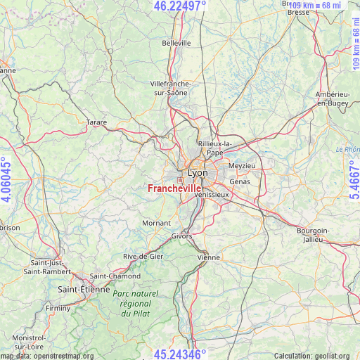
Francheville GPS coordinates[2]
45° 44' 10.932" North, 4° 45' 48.888" East
| Map corner | latitude | longitude |
|---|---|---|
| Upper-left | 46.22497°, | 4.06045° |
| Center: | 45.73637°, | 4.76358° |
| Lower-right: | 45.24346°, | 5.4667° |
| Map W x H: | 109.1×109.1 km | = 67.8×67.8mi |
| max Lat: | 51.07786° ⇑70.3% North |
| Francheville: | 45.73637° |
| min Lat: | ⇓29.7% South 41.3874° |
| min Long | Francheville | max Long |
| -5.08615° | 4.76358° | 9.52242° |
| W 74.5%⇐ | ⇒25.5% E |
Elevation
Elevation of Francheville is 208 m = 682 ft, and this is 14.3 m = 47 ft above average elevation for this country.
| Max E: |
2333 m = 7654 ft | 32.2% |
| Francheville | 208 m 682 ft | |
| Avg. | 193.7 m = 635 ft | |
Min E: |
-1 m = -3 ft | 67.8% |
See also: France elevation on elevation.city.
Geographical zone
Francheville is located in North temperate zone (between Tropic of Cancer and the Arctic Circle). Distance of this North polar circle is 2315.8 km =1439 mi to North.| Distance of | km | miles | from Francheville |
|---|---|---|---|
| North Pole | 4921.7 | 3058.2 | to North |
| Arctic Circle | 2315.8 | 1439 | to North |
| Tropic Cancer | 2479.5 | 1540.7 | to South |
| Equator | 5085.4 | 3159.9 | to South |


Nearby cities:
15 places around Francheville: (largest is in red/bold)
• Brindas
5.7 km =3.5 mi,  252°
252°
• Champagne-au-Mont-d’Or
6.8 km =4.2 mi,  18°
18°
• Chaponost
3.3 km =2.1 mi,  209°
209°
• Charbonnières-les-Bains
5.1 km =3.2 mi,  344°
344°
• Craponne
3.3 km =2.1 mi,  287°
287°
• Grézieu-la-Varenne
5.8 km =3.6 mi,  282°
282°
• La Mulatière
3.9 km =2.4 mi,  103°
103°
• Lyon
6.6 km =4.1 mi,  78°
78°
• Oullins
4.2 km =2.6 mi,  126°
126°
• Pierre-Bénite
6 km =3.7 mi, 127°
• Saint-Genis-Laval
5.1 km =3.2 mi,  153°
153°
• Saint-Genis-les-Ollières
3.7 km =2.3 mi,  308°
308°
• Sainte-Foy-lès-Lyon
3 km =1.9 mi, 95°
• Tassin-la-Demi-Lune
2.8 km =1.7 mi,  42°
42°
• Écully
4.4 km =2.7 mi,  14°
14°
Sources, notices
• [Note1] Compared only with cities in France existing in our database
• [Src1] Map data: © OpenStreetMap contributors (CC-BY-SA)
• [Src2] Other city data from geonames.org with taken over terms of usage.
• [Src3] Geographical zone / Annual Mean Temperature by Robert A. Rohde @ Wikipedia
