Les Riceys geodata
Les Riceys (Grand Est) is a populated place; located in France in Europe/Paris (GMT+2) time zone. With population of 1,401 people, there are 6604 cities with bigger population in this country. Compared to other cities in France, 59.1% of cities are located further ↓South; 71.1% of cities are located further ←West and 61.6% of cities have lower elevation than Les Riceys. Note1
Administrative division(s):
- Level 1: Grand Est
- Level 2: Département de l'Aube
- Level 3: Arrondissement de Troyes
- Level 4: Les Riceys


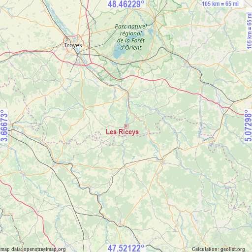
Les Riceys GPS coordinates[2]
47° 59' 38.04" North, 4° 22' 11.496" East
| Map corner | latitude | longitude |
|---|---|---|
| Upper-left | 48.46229°, | 3.66673° |
| Center: | 47.9939°, | 4.36986° |
| Lower-right: | 47.52122°, | 5.07298° |
| Map W x H: | 104.6×104.6 km | = 65×65mi |
| max Lat: | 51.07786° ⇑40.9% North |
| Les Riceys: | 47.9939° |
| min Lat: | ⇓59.1% South 41.3874° |
| min Long | Les Riceys | max Long |
| -5.08615° | 4.36986° | 9.52242° |
| W 71.1%⇐ | ⇒28.9% E |
Elevation
Elevation of Les Riceys is 178 m = 584 ft, and this is 15.7 m = 52 ft below average elevation for this country.
| Max E: |
2333 m = 7654 ft | 38.4% |
| Avg. | 193.7 m = 635 ft | |
| Les Riceys | 178 m = 584 ft | |
Min E: |
-1 m = -3 ft | 61.6% |
See also: France elevation on elevation.city.
Geographical zone
Les Riceys is located in North temperate zone (between Tropic of Cancer and the Arctic Circle). Distance of this North polar circle is 2064.8 km =1283 mi to North.| Distance of | km | miles | from Les Riceys |
|---|---|---|---|
| North Pole | 4670.6 | 2902.2 | to North |
| Arctic Circle | 2064.8 | 1283 | to North |
| Tropic Cancer | 2730.5 | 1696.7 | to South |
| Equator | 5336.4 | 3315.9 | to South |


Nearby cities:
15 places around Les Riceys: (largest is in red/bold)
• Bar-sur-Seine
13.2 km =8.2 mi,  2°
2°
• Chaource
18.7 km =11.6 mi,  292°
292°
• Châtillon-sur-Seine
21.4 km =13.3 mi,  134°
134°
• Clérey
27.4 km =17 mi,  331°
331°
• Essoyes
14.1 km =8.8 mi,  60°
60°
• Gyé-sur-Seine
5.9 km =3.7 mi,  47°
47°
• Laignes
16.8 km =10.4 mi,  181°
181°
• Landreville
11.7 km =7.3 mi,  40°
40°
• Mussy-sur-Seine
9.7 km =6 mi,  100°
100°
• Saint-Parres-lès-Vaudes
22.7 km =14.1 mi, 329°
• Tanlay
26.9 km =16.7 mi,  232°
232°
• Vaudes
24.5 km =15.2 mi, 326°
• Vendeuvre-sur-Barse
28.1 km =17.5 mi,  15°
15°
• Villemoyenne
23.1 km =14.4 mi, 332°
• Virey-sous-Bar
16.8 km =10.4 mi,  344°
344°
Sources, notices
• [Note1] Compared only with cities in France existing in our database
• [Src1] Map data: © OpenStreetMap contributors (CC-BY-SA)
• [Src2] Other city data from geonames.org with taken over terms of usage.
• [Src3] Geographical zone / Annual Mean Temperature by Robert A. Rohde @ Wikipedia
