Châtillon-sur-Seine geodata
Châtillon-sur-Seine (Bourgogne-Franche-Comté) is a populated place; located in France in Europe/Paris (GMT+2) time zone. With population of 6,939 people, there are 1428 cities with bigger population in this country. Compared to other cities in France, 56.7% of cities are located further ↓South; 72.6% of cities are located further ←West and 70.1% of cities have lower elevation than Châtillon-sur-Seine. Note1
Administrative division(s):
- Level 1: Bourgogne-Franche-Comté
- Level 2: Département de la Côte-d'Or
- Level 3: Arrondissement de Montbard
- Level 4: Châtillon-sur-Seine


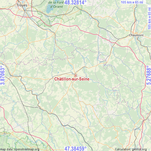
Châtillon-sur-Seine GPS coordinates[2]
47° 51' 30.636" North, 4° 34' 25.5" East
| Map corner | latitude | longitude |
|---|---|---|
| Upper-left | 48.32814°, | 3.87063° |
| Center: | 47.85851°, | 4.57375° |
| Lower-right: | 47.38459°, | 5.27688° |
| Map W x H: | 104.9×104.9 km | = 65.2×65.2mi |
| max Lat: | 51.07786° ⇑43.3% North |
| Châtillon-sur-Seine: | 47.85851° |
| min Lat: | ⇓56.7% South 41.3874° |
| min Long | Châtillon-sur- | max Long |
| -5.08615° | 4.57375° | 9.52242° |
| W 72.6%⇐ | ⇒27.4% E |
Elevation
Elevation of Châtillon-sur-Seine is 220 m = 722 ft, and this is 26.3 m = 86 ft above average elevation for this country.
| Max E: |
2333 m = 7654 ft | 29.9% |
| Châtillon-sur-Seine | 220 m 722 ft | |
| Avg. | 193.7 m = 635 ft | |
Min E: |
-1 m = -3 ft | 70.1% |
See also: France elevation on elevation.city.
Geographical zone
Châtillon-sur-Seine is located in North temperate zone (between Tropic of Cancer and the Arctic Circle). Distance of this North polar circle is 2079.8 km =1292.3 mi to North.| Distance of | km | miles | from Châtillon-sur-Seine |
|---|---|---|---|
| North Pole | 4685.7 | 2911.6 | to North |
| Arctic Circle | 2079.8 | 1292.3 | to North |
| Tropic Cancer | 2715.4 | 1687.3 | to South |
| Equator | 5321.4 | 3306.6 | to South |


Nearby cities:
15 places around Châtillon-sur-Seine: (largest is in red/bold)
• Ancy-le-Franc
32 km =19.9 mi,  253°
253°
• Arc-en-Barrois
33.9 km =21.1 mi,  72°
72°
• Bar-sur-Seine
31.9 km =19.8 mi,  332°
332°
• Châteauvillain
32.4 km =20.1 mi,  52°
52°
• Essoyes
22.3 km =13.9 mi,  352°
352°
• Gyé-sur-Seine
21.9 km =13.6 mi, 330°
• Laignes
15.7 km =9.8 mi,  263°
263°
• Landreville
25.1 km =15.6 mi,  342°
342°
• Les Riceys
21.4 km =13.3 mi,  314°
314°
• Montbard
31.6 km =19.6 mi,  214°
214°
• Mussy-sur-Seine
14.4 km =8.9 mi, 336°
• Ravières
29.3 km =18.2 mi,  241°
241°
• Saint-Rémy
32.1 km =19.9 mi,  220°
220°
• Venarey-les-Laumes
36.2 km =22.5 mi,  193°
193°
• Ville-sous-la-Ferté
33.3 km =20.7 mi,  28°
28°
Sources, notices
• [Note1] Compared only with cities in France existing in our database
• [Src1] Map data: © OpenStreetMap contributors (CC-BY-SA)
• [Src2] Other city data from geonames.org with taken over terms of usage.
• [Src3] Geographical zone / Annual Mean Temperature by Robert A. Rohde @ Wikipedia
