Saint-Geniez-d’Olt geodata
Saint-Geniez-d’Olt (Occitanie) is a populated place; located in France in Europe/Paris (GMT+2) time zone. With population of 2,068 people, there are 4642 cities with bigger population in this country. Compared to other cities in France, 83.8% of cities are located further ↑North; 57.4% of cities are located further ←West and 90.2% of cities have lower elevation than Saint-Geniez-d’Olt. Note1
Administrative division(s):
- Level 1: Occitanie
- Level 2: Département de l'Aveyron
- Level 3: Arrondissement de Rodez
- Level 4: Saint Geniez d'Olt et d'Aubrac


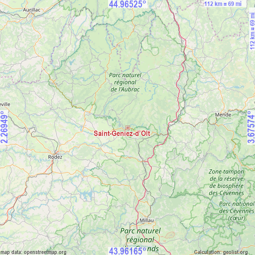
Saint-Geniez-d’Olt GPS coordinates[2]
44° 27' 56.196" North, 2° 58' 21.396" East
| Map corner | latitude | longitude |
|---|---|---|
| Upper-left | 44.96525°, | 2.26949° |
| Center: | 44.46561°, | 2.97261° |
| Lower-right: | 43.96165°, | 3.67574° |
| Map W x H: | 111.6×111.6 km | = 69.3×69.3mi |
| max Lat: | 51.07786° ⇑83.8% North |
| Saint-Geniez-d’Olt: | 44.46561° |
| min Lat: | ⇓16.2% South 41.3874° |
| min Long | Saint-Geniez-d� | max Long |
| -5.08615° | 2.97261° | 9.52242° |
| W 57.4%⇐ | ⇒42.6% E |
Elevation
Elevation of Saint-Geniez-d’Olt is 431 m = 1414 ft, and this is 237.3 m = 779 ft above average elevation for this country.
| Max E: |
2333 m = 7654 ft | 9.8% |
| Saint-Geniez-d’Olt | 431 m 1414 ft | |
| Avg. | 193.7 m = 635 ft | |
Min E: |
-1 m = -3 ft | 90.2% |
See also: France elevation on elevation.city.
Geographical zone
Saint-Geniez-d’Olt is located in North temperate zone (between Tropic of Cancer and the Arctic Circle). Distance of this Northern Tropic circle is 2338.2 km =1452.9 mi to South.| Distance of | km | miles | from Saint-Geniez-d’Olt |
|---|---|---|---|
| North Pole | 5062.9 | 3145.9 | to North |
| Arctic Circle | 2457.1 | 1526.8 | to North |
| Tropic Cancer | 2338.2 | 1452.9 | to South |
| Equator | 4944.1 | 3072.1 | to South |


Nearby cities:
15 places around Saint-Geniez-d’Olt: (largest is in red/bold)
• Banassac
18.3 km =11.4 mi,  100°
100°
• Bertholène
17.2 km =10.7 mi,  242°
242°
• Bozouls
19.7 km =12.2 mi,  271°
271°
• Castelnau-de-Mandailles
10.8 km =6.7 mi,  320°
320°
• Coubisou
21.6 km =13.4 mi,  296°
296°
• Espalion
17.8 km =11.1 mi,  290°
290°
• La Canourgue
19.7 km =12.2 mi, 101°
• Laissac
15.3 km =9.5 mi,  231°
231°
• Lapanouse
15.1 km =9.4 mi,  162°
162°
• Le Monastier-Pin-Moriès
22.7 km =14.1 mi,  75°
75°
• Nasbinals
22.7 km =14.1 mi,  15°
15°
• Saint-Germain-du-Teil
15.9 km =9.9 mi, 84°
• Ségur
22.2 km =13.8 mi,  209°
209°
• Sévérac-le-Château
17.2 km =10.7 mi, 156°
• Vézins-de-Lévézou
20.8 km =12.9 mi,  184°
184°
Sources, notices
• [Note1] Compared only with cities in France existing in our database
• [Src1] Map data: © OpenStreetMap contributors (CC-BY-SA)
• [Src2] Other city data from geonames.org with taken over terms of usage.
• [Src3] Geographical zone / Annual Mean Temperature by Robert A. Rohde @ Wikipedia
