Nasbinals geodata
Nasbinals (Occitanie) is a populated place; located in France in Europe/Paris (GMT+2) time zone. With population of 502 people, there are 15200 cities with bigger population in this country. Compared to other cities in France, 82.4% of cities are located further ↑North; 58.4% of cities are located further ←West and 99.6% of cities have lower elevation than Nasbinals. Note1
Administrative division(s):
- Level 1: Occitanie
- Level 2: Département de la Lozère
- Level 3: Arrondissement de Mende
- Level 4: Nasbinals


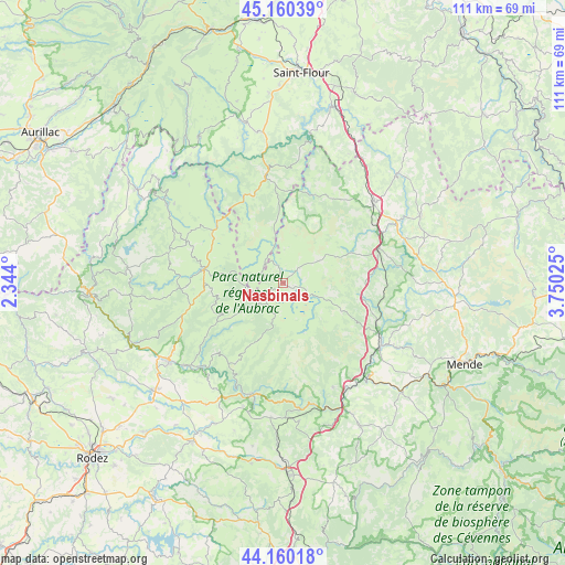
Nasbinals GPS coordinates[2]
44° 39' 44.784" North, 3° 2' 49.632" East
| Map corner | latitude | longitude |
|---|---|---|
| Upper-left | 45.16039°, | 2.344° |
| Center: | 44.66244°, | 3.04712° |
| Lower-right: | 44.16018°, | 3.75025° |
| Map W x H: | 111.2×111.2 km | = 69.1×69.1mi |
| max Lat: | 51.07786° ⇑82.4% North |
| Nasbinals: | 44.66244° |
| min Lat: | ⇓17.6% South 41.3874° |
| min Long | Nasbinals | max Long |
| -5.08615° | 3.04712° | 9.52242° |
| W 58.4%⇐ | ⇒41.6% E |
Elevation
Elevation of Nasbinals is 1176 m = 3858 ft, and this is 982.3 m = 3223 ft above average elevation for this country.
| Max E: |
2333 m = 7654 ft | 0.40000000000001% |
| Nasbinals | 1176 m 3858 ft | |
| Avg. | 193.7 m = 635 ft | |
Min E: |
-1 m = -3 ft | 99.6% |
See also: France elevation on elevation.city.
Geographical zone
Nasbinals is located in North temperate zone (between Tropic of Cancer and the Arctic Circle). Distance of this Northern Tropic circle is 2360.1 km =1466.5 mi to South.| Distance of | km | miles | from Nasbinals |
|---|---|---|---|
| North Pole | 5041.1 | 3132.4 | to North |
| Arctic Circle | 2435.2 | 1513.2 | to North |
| Tropic Cancer | 2360.1 | 1466.5 | to South |
| Equator | 4966 | 3085.7 | to South |


Nearby cities:
15 places around Nasbinals: (largest is in red/bold)
• Aumont-Aubrac
19.9 km =12.4 mi,  70°
70°
• Castelnau-de-Mandailles
18.7 km =11.6 mi,  223°
223°
• Chaudes-Aigues
21.6 km =13.4 mi,  350°
350°
• Chirac
23.3 km =14.5 mi,  131°
131°
• Espalion
27.4 km =17 mi,  235°
235°
• Laguiole
16 km =9.9 mi,  278°
278°
• Le Monastier-Pin-Moriès
22.8 km =14.2 mi,  135°
135°
• Marvejols
22.8 km =14.2 mi,  122°
122°
• Montpeyroux
17.8 km =11.1 mi,  262°
262°
• Montrodat
25.6 km =15.9 mi, 119°
• Rimeize
24.7 km =15.3 mi,  62°
62°
• Saint-Chély-d’Apcher
24 km =14.9 mi,  48°
48°
• Saint-Geniez-d’Olt
22.7 km =14.1 mi,  195°
195°
• Saint-Germain-du-Teil
22.7 km =14.1 mi,  154°
154°
• Saint-Urcize
5.1 km =3.2 mi,  318°
318°
Sources, notices
• [Note1] Compared only with cities in France existing in our database
• [Src1] Map data: © OpenStreetMap contributors (CC-BY-SA)
• [Src2] Other city data from geonames.org with taken over terms of usage.
• [Src3] Geographical zone / Annual Mean Temperature by Robert A. Rohde @ Wikipedia
