La Croix-Valmer geodata
La Croix-Valmer (Provence-Alpes-Côte d'Azur) is a populated place; located in France in Europe/Paris (GMT+2) time zone. With population of 3,050 people, there are 3190 cities with bigger population in this country. Compared to other cities in France, 97% of cities are located further ↑North; 92.1% of cities are located further ←West and 53.3% of cities have higher elevation than La Croix-Valmer. Note1
Administrative division(s):
- Level 1: Provence-Alpes-Côte d'Azur
- Level 2: Var
- Level 3: Arrondissement de Draguignan
- Level 4: La Croix-Valmer


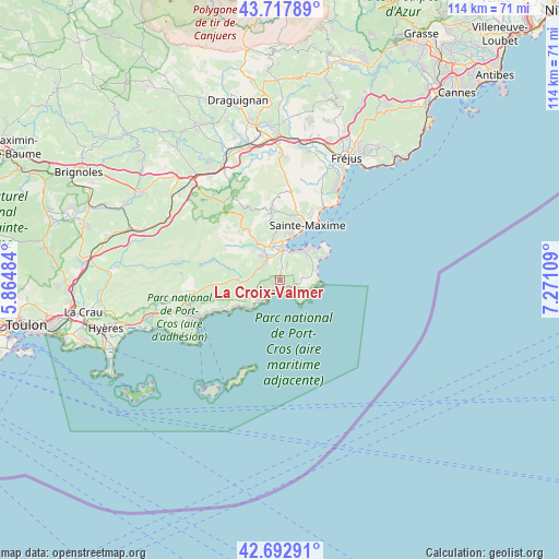
La Croix-Valmer GPS coordinates[2]
43° 12' 27.18" North, 6° 34' 4.656" East
| Map corner | latitude | longitude |
|---|---|---|
| Upper-left | 43.71789°, | 5.86484° |
| Center: | 43.20755°, | 6.56796° |
| Lower-right: | 42.69291°, | 7.27109° |
| Map W x H: | 114×114 km | = 70.8×70.8mi |
| max Lat: | 51.07786° ⇑97% North |
| La Croix-Valmer: | 43.20755° |
| min Lat: | ⇓3% South 41.3874° |
| min Long | La Croix-Valmer | max Long |
| -5.08615° | 6.56796° | 9.52242° |
| W 92.1%⇐ | ⇒7.9% E |
Elevation
Elevation of La Croix-Valmer is 121 m = 397 ft, and this is 72.7 m = 239 ft below average elevation for this country.
| Max E: |
2333 m = 7654 ft | 53.3% |
| Avg. | 193.7 m = 635 ft | |
| La Croix-Valmer | 121 m = 397 ft | |
Min E: |
-1 m = -3 ft | 46.7% |
See also: France elevation on elevation.city.
Geographical zone
La Croix-Valmer is located in North temperate zone (between Tropic of Cancer and the Arctic Circle). Distance of this Northern Tropic circle is 2198.3 km =1366 mi to South.| Distance of | km | miles | from La Croix-Valmer |
|---|---|---|---|
| North Pole | 5202.8 | 3232.9 | to North |
| Arctic Circle | 2596.9 | 1613.6 | to North |
| Tropic Cancer | 2198.3 | 1366 | to South |
| Equator | 4804.2 | 2985.2 | to South |


Nearby cities:
15 places around La Croix-Valmer: (largest is in red/bold)
• Bormes-les-Mimosas
19.3 km =12 mi,  251°
251°
• Cavalaire-sur-Mer
5 km =3.1 mi,  218°
218°
• Cogolin
5.9 km =3.7 mi,  328°
328°
• Collobrières
21.2 km =13.2 mi,  278°
278°
• Gassin
2.8 km =1.7 mi,  30°
30°
• Gonfaron
25.8 km =16 mi,  299°
299°
• Grimaud
8.2 km =5.1 mi, 332°
• La Garde-Freinet
14.6 km =9.1 mi, 326°
• La Môle
8.2 km =5.1 mi,  269°
269°
• Le Lavandou
18.2 km =11.3 mi,  244°
244°
• Le Plan-de-la-Tour
14.1 km =8.8 mi,  354°
354°
• Les Mayons
20.6 km =12.8 mi, 304°
• Ramatuelle
3.7 km =2.3 mi,  75°
75°
• Saint-Tropez
8.9 km =5.5 mi,  41°
41°
• Sainte-Maxime
12.7 km =7.9 mi, 26°
Sources, notices
• [Note1] Compared only with cities in France existing in our database
• [Src1] Map data: © OpenStreetMap contributors (CC-BY-SA)
• [Src2] Other city data from geonames.org with taken over terms of usage.
• [Src3] Geographical zone / Annual Mean Temperature by Robert A. Rohde @ Wikipedia
