Gassin geodata
Gassin (Provence-Alpes-Côte d'Azur) is a populated place; located in France in Europe/Paris (GMT+2) time zone. With population of 2,949 people, there are 3303 cities with bigger population in this country. Compared to other cities in France, 96.8% of cities are located further ↑North; 92.3% of cities are located further ←West and 62.5% of cities have lower elevation than Gassin. Note1
Administrative division(s):
- Level 1: Provence-Alpes-Côte d'Azur
- Level 2: Var
- Level 3: Arrondissement de Draguignan
- Level 4: Gassin


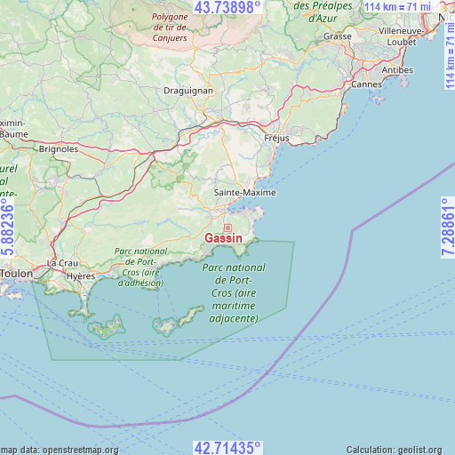
Gassin GPS coordinates[2]
43° 13' 43.752" North, 6° 35' 7.764" East
| Map corner | latitude | longitude |
|---|---|---|
| Upper-left | 43.73898°, | 5.88236° |
| Center: | 43.22882°, | 6.58549° |
| Lower-right: | 42.71435°, | 7.28861° |
| Map W x H: | 113.9×113.9 km | = 70.8×70.8mi |
| max Lat: | 51.07786° ⇑96.8% North |
| Gassin: | 43.22882° |
| min Lat: | ⇓3.2% South 41.3874° |
| min Long | Gassin | max Long |
| -5.08615° | 6.58549° | 9.52242° |
| W 92.3%⇐ | ⇒7.7% E |
Elevation
Elevation of Gassin is 182 m = 597 ft, and this is 11.7 m = 38 ft below average elevation for this country.
| Max E: |
2333 m = 7654 ft | 37.5% |
| Avg. | 193.7 m = 635 ft | |
| Gassin | 182 m = 597 ft | |
Min E: |
-1 m = -3 ft | 62.5% |
See also: France elevation on elevation.city.
Geographical zone
Gassin is located in North temperate zone (between Tropic of Cancer and the Arctic Circle). Distance of this Northern Tropic circle is 2200.7 km =1367.5 mi to South.| Distance of | km | miles | from Gassin |
|---|---|---|---|
| North Pole | 5200.5 | 3231.4 | to North |
| Arctic Circle | 2594.6 | 1612.2 | to North |
| Tropic Cancer | 2200.7 | 1367.5 | to South |
| Equator | 4806.6 | 2986.7 | to South |


Nearby cities:
15 places around Gassin: (largest is in red/bold)
• Bormes-les-Mimosas
21.5 km =13.4 mi,  246°
246°
• Cavalaire-sur-Mer
7.7 km =4.8 mi,  215°
215°
• Cogolin
5.2 km =3.2 mi,  300°
300°
• Collobrières
22.4 km =13.9 mi,  272°
272°
• Grimaud
7.2 km =4.5 mi,  313°
313°
• La Croix-Valmer
2.8 km =1.7 mi,  210°
210°
• La Garde-Freinet
13.6 km =8.5 mi,  316°
316°
• La Môle
9.9 km =6.2 mi,  255°
255°
• Le Lavandou
20.5 km =12.7 mi,  240°
240°
• Le Plan-de-la-Tour
12 km =7.5 mi,  346°
346°
• Les Mayons
20.6 km =12.8 mi, 296°
• Ramatuelle
2.5 km =1.6 mi,  124°
124°
• Roquebrune-sur-Argens
24.2 km =15 mi,  10°
10°
• Saint-Tropez
6.2 km =3.9 mi,  45°
45°
• Sainte-Maxime
9.9 km =6.2 mi,  25°
25°
Sources, notices
• [Note1] Compared only with cities in France existing in our database
• [Src1] Map data: © OpenStreetMap contributors (CC-BY-SA)
• [Src2] Other city data from geonames.org with taken over terms of usage.
• [Src3] Geographical zone / Annual Mean Temperature by Robert A. Rohde @ Wikipedia
