Cavalaire-sur-Mer geodata
Cavalaire-sur-Mer (Provence-Alpes-Côte d'Azur) is a populated place; located in France in Europe/Paris (GMT+2) time zone. With population of 5,670 people, there are 1749 cities with bigger population in this country. Compared to other cities in France, 97.4% of cities are located further ↑North; 91.9% of cities are located further ←West and 55% of cities have lower elevation than Cavalaire-sur-Mer. Note1
Administrative division(s):
- Level 1: Provence-Alpes-Côte d'Azur
- Level 2: Var
- Level 3: Arrondissement de Draguignan
- Level 4: Cavalaire-sur-Mer


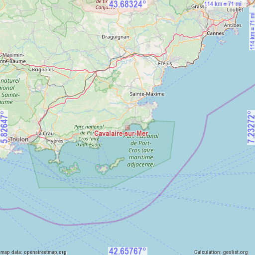
Cavalaire-sur-Mer GPS coordinates[2]
43° 10' 21.396" North, 6° 31' 46.524" East
| Map corner | latitude | longitude |
|---|---|---|
| Upper-left | 43.68324°, | 5.82647° |
| Center: | 43.17261°, | 6.52959° |
| Lower-right: | 42.65767°, | 7.23272° |
| Map W x H: | 114×114 km | = 70.8×70.8mi |
| max Lat: | 51.07786° ⇑97.4% North |
| Cavalaire-sur-Mer: | 43.17261° |
| min Lat: | ⇓2.6% South 41.3874° |
| min Long | Cavalaire-sur-M | max Long |
| -5.08615° | 6.52959° | 9.52242° |
| W 91.9%⇐ | ⇒8.1% E |
Elevation
Elevation of Cavalaire-sur-Mer is 150 m = 492 ft, and this is 43.7 m = 143 ft below average elevation for this country.
| Max E: |
2333 m = 7654 ft | 45% |
| Avg. | 193.7 m = 635 ft | |
| Cavalaire-sur-Mer | 150 m = 492 ft | |
Min E: |
-1 m = -3 ft | 55% |
See also: France elevation on elevation.city.
Geographical zone
Cavalaire-sur-Mer is located in North temperate zone (between Tropic of Cancer and the Arctic Circle). Distance of this Northern Tropic circle is 2194.4 km =1363.5 mi to South.| Distance of | km | miles | from Cavalaire-sur-Mer |
|---|---|---|---|
| North Pole | 5206.7 | 3235.3 | to North |
| Arctic Circle | 2600.8 | 1616.1 | to North |
| Tropic Cancer | 2194.4 | 1363.5 | to South |
| Equator | 4800.3 | 2982.8 | to South |


Nearby cities:
15 places around Cavalaire-sur-Mer: (largest is in red/bold)
• Bormes-les-Mimosas
15.4 km =9.6 mi,  261°
261°
• Cogolin
8.9 km =5.5 mi,  0°
0°
• Collobrières
19.3 km =12 mi,  291°
291°
• Gassin
7.7 km =4.8 mi,  35°
35°
• Grimaud
11.2 km =7 mi,  356°
356°
• La Croix-Valmer
5 km =3.1 mi, 38°
• La Garde-Freinet
16.8 km =10.4 mi,  343°
343°
• La Londe-les-Maures
24.3 km =15.1 mi, 260°
• La Môle
6.4 km =4 mi,  307°
307°
• Le Lavandou
13.8 km =8.6 mi,  253°
253°
• Le Plan-de-la-Tour
17.9 km =11.1 mi,  5°
5°
• Les Mayons
20.9 km =13 mi,  318°
318°
• Ramatuelle
8.2 km =5.1 mi,  54°
54°
• Saint-Tropez
13.9 km =8.6 mi, 40°
• Sainte-Maxime
17.6 km =10.9 mi,  30°
30°
Sources, notices
• [Note1] Compared only with cities in France existing in our database
• [Src1] Map data: © OpenStreetMap contributors (CC-BY-SA)
• [Src2] Other city data from geonames.org with taken over terms of usage.
• [Src3] Geographical zone / Annual Mean Temperature by Robert A. Rohde @ Wikipedia
